IMAGES TAKEN NEAR TO
Blackmoor, LISS, GU33 6DE
Introduction
This page details the photographs taken nearby to GU33 6DE by members of the Geograph project.
The Geograph project started in 2005 with the aim of publishing, organising and preserving representative images for every square kilometre of Great Britain, Ireland and the Isle of Man.

There are currently over 7.5m images from over14,400 individuals and you can help contribute to the project by visiting https://www.geograph.org.uk
Image Map
Images are licensed for reuse under creativecommons.org/licenses/by-sa/2.0
Notes
- Clicking on the map will re-center to the selected point.
- The higher the marker number, the further away the image location is from the centre of the postcode.
Image Listing (7 Images Found)
Images are licensed for reuse under creativecommons.org/licenses/by-sa/2.0
Image
Details
Distance
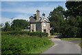
1
The Bradshott Oast, Blackmoor, Liss, Hampshire
Image: © Oast House Archive
Taken: 24 Jun 2009
0.07 miles
3
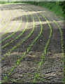
Young maize
Looking more like a running track.
Image: © Hugh Chevallier
Taken: 17 Jun 2012
0.16 miles
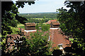
4
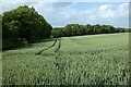
Farmland, Selborne
A crop of wheat to the west of Bradshott Hall.
Image: © Andrew Smith
Taken: 11 Jun 2022
0.19 miles
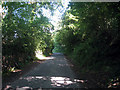
5
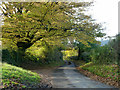
Lane to Empshott
It does not seem to have a specific name.
Image: © Robin Webster
Taken: 16 Nov 2013
0.19 miles
6
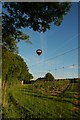
Balloon over SU7531 and the orchard in this grid.
Image: © Andrya Prescott
Taken: 3 Jun 2006
0.23 miles