IMAGES TAKEN NEAR TO
Normandy Common Lane, GUILDFORD, GU3 2AP
Introduction
This page details the photographs taken nearby to Normandy Common Lane, GU3 2AP by members of the Geograph project.
The Geograph project started in 2005 with the aim of publishing, organising and preserving representative images for every square kilometre of Great Britain, Ireland and the Isle of Man.

There are currently over 7.5m images from over14,400 individuals and you can help contribute to the project by visiting https://www.geograph.org.uk
Image Map
Images are licensed for reuse under creativecommons.org/licenses/by-sa/2.0
Notes
- Clicking on the map will re-center to the selected point.
- The higher the marker number, the further away the image location is from the centre of the postcode.
Image Listing (31 Images Found)
Images are licensed for reuse under creativecommons.org/licenses/by-sa/2.0
Image
Details
Distance
1
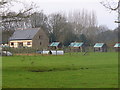
Hunts Hill Farm, Normandy
Pig and poultry rearing in the West Surrey countryside at Normandy.
normandyhistorians.co.uk
Image: © Colin Smith
Taken: 21 Jan 2011
0.03 miles
2
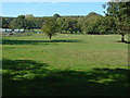
Hunts Hill Farm
One of the fields at the back of the farm.
Image: © Alan Hunt
Taken: 2 Oct 2011
0.05 miles
3
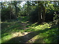
Normandy Common
A path through the woods, much used as a play area by the local children.
Image: © Alan Hunt
Taken: 2 Oct 2011
0.05 miles
4
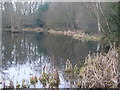
Normandy Pond
Reed-fringed and wooded pond at the eastern end of Normandy Common.
Image: © Colin Smith
Taken: 21 Jan 2011
0.12 miles
5

Normandy Pond
The pond is on Normandy Common and is a SNCI (Site of Nature Conservation Importance). It is probably not natural and was possibly dug for sand extraction in the eighteenth century. It was apparently in a very overgrown state by the mid-1980s when local residents, under the umbrella of Normandy Parish Council, volunteered to restore it. Read here http://www.normandyhistorians.guildford-surrey.co.uk/pond.html for the full story of the restoration.
The photograph was taken late in the afternoon of a day during a period of weather with continual clear skies resulting in cold nights and comparatively warm days for February. Despite the ambient temperature of around 8º Centigrade at the time, the pond had not unfrozen at all during the day.
Image: © Nigel Cox
Taken: 17 Feb 2008
0.12 miles
6
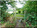
Stile on footpath going south to Guildford Road
Image: © Shazz
Taken: 4 Aug 2014
0.14 miles
7
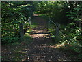
Normandy Common
The footbridge over the drain that runs across the common. The footpath runs from Normandy Common lane to the scout hall carpark.
Image: © Alan Hunt
Taken: 2 Oct 2011
0.14 miles
8
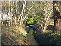
Stream at Normandy Common
Narrow and wooded stream flowing in the direction of Normandy Pond.
normandyhistorians.co.uk
Image: © Colin Smith
Taken: 21 Jan 2011
0.15 miles
9
Stile at footpath junction near Hunts Hill Farm
A picture from 2011 is at http://www.geograph.org.uk/photo/2240492.
Image: © Shazz
Taken: 4 Aug 2014
0.17 miles
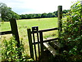
10
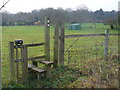
Stile Near Hunts Hill Farm
Wooden stile and meadows near to Hunts Hill Farm, Normandy.
normandyhistorians.co.uk
Image: © Colin Smith
Taken: 21 Jan 2011
0.17 miles