IMAGES TAKEN NEAR TO
The Spain, PETERSFIELD, GU32 3JZ
Introduction
This page details the photographs taken nearby to The Spain, GU32 3JZ by members of the Geograph project.
The Geograph project started in 2005 with the aim of publishing, organising and preserving representative images for every square kilometre of Great Britain, Ireland and the Isle of Man.

There are currently over 7.5m images from over14,400 individuals and you can help contribute to the project by visiting https://www.geograph.org.uk
Image Map (Loading...)


Getting Data...Please wait
Leaflet Map data © OpenStreetMap
Images are licensed for reuse under creativecommons.org/licenses/by-sa/2.0
Notes
- Clicking on the map will re-center to the selected point.
- The higher the marker number, the further away the image location is from the centre of the postcode.
Image Listing (1601 Images Found)
Images are licensed for reuse under creativecommons.org/licenses/by-sa/2.0
Image
Details
Distance
1
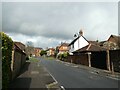
18: Going through a tightwind (clockwise)
Looking north-west in The Spain
Image: © Basher Eyre
Taken: 12 Mar 2022
0.00 miles
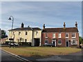
2
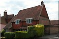
9 The Spain Petersfield
Once the Bricklayers Arms public house.
Image: © David960
Taken: 16 Feb 2014
0.01 miles
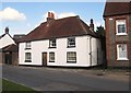
4
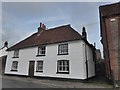
The Spain, Petersfield
The origin of this unusual street name is uncertain. It may relate to Spanish merchants who traded here at the time when Petersfield was an important wool town, or it could be a corruption of 'spayne' meaning tile suggesting that the buildings here had roof tiles rather than thatch.
Image: © Stephen McKay
Taken: 28 Nov 2017
0.02 miles
5

"Goodyers", The Spain, Petersfield
This plaque is on "Goodyers" which was the home of botanist John Goodyer. The area known as "The Spain" is thought to be named for Spanish wool merchants who lived here in medieval times.
Image: © Martyn Pattison
Taken: 9 Jun 2005
0.02 miles
6
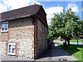
"Tullys" in The Spain.
This is reputed to be the oldest house in Petersfield and dates from the 15th C. It consists of two remaining bays of a Wealden halled house and is over the stone cellar of mediaeval house.
Image: © Martyn Pattison
Taken: 9 Jun 2005
0.02 miles
7
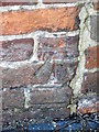
Bench Mark, The Spain, Petersfield
The bench mark is to be found on the wall of the building, for a wider view http://www.geograph.org.uk/photo/2048696 and for further information on the cut mark http://www.bench-marks.org.uk/bm35389
A bench mark is an Ordnance Survey arrowhead sign found on walls, bridges, churches and specially erected triangulation pillars where the altitude above sea-level has been accurately measured by surveyors. The arrowhead points to a horizontal line above it which marks the exact altitude.
With rivets and pivots there is no datum (horizontal line) cut, the pointed-to horizontal surface defining the datum height.
Image: © Maigheach-gheal
Taken: 31 Aug 2010
0.02 miles
8
No. 28 The Spain, Petersfield
There is an Ordnance Survey bench mark on the wall nearest the pavement.
Image: © Maigheach-gheal
Taken: 31 Aug 2010
0.02 miles
9
2020 vision: Day 34
House in The Spain, at one time "The Bricklayers Arms"
10C
1st headline BBC Radio "Today" programme 6am: Streatham attack: Police search homes as attacker Sudesh Amman named
Image: © Basher Eyre
Taken: 3 Feb 2020
0.02 miles
10
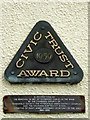
Plaque, Spain House
These two plaques are attached to the front of Spain House.
Image: © Maigheach-gheal
Taken: 16 Oct 2011
0.03 miles