IMAGES TAKEN NEAR TO
Bannerman Road, PETERSFIELD, GU32 2HQ
Introduction
This page details the photographs taken nearby to Bannerman Road, GU32 2HQ by members of the Geograph project.
The Geograph project started in 2005 with the aim of publishing, organising and preserving representative images for every square kilometre of Great Britain, Ireland and the Isle of Man.

There are currently over 7.5m images from over14,400 individuals and you can help contribute to the project by visiting https://www.geograph.org.uk
Image Map (Loading...)


Getting Data...Please wait
Leaflet Map data © OpenStreetMap
Images are licensed for reuse under creativecommons.org/licenses/by-sa/2.0
Notes
- Clicking on the map will re-center to the selected point.
- The higher the marker number, the further away the image location is from the centre of the postcode.
Image Listing (741 Images Found)
Images are licensed for reuse under creativecommons.org/licenses/by-sa/2.0
Image
Details
Distance
1
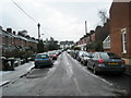
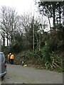
Bannerman Road
Once Petersfield's shortest road, but now extended at the end.
Image: © Basher Eyre
Taken: 20 Feb 2008
0.02 miles
3
Storm Eunice: the clear up begins
The Great Storms of 1987 and 1990 it was not, but here in Tilmore Road a fallen tree did need to be removed....
Image: © Basher Eyre
Taken: 19 Feb 2022
0.03 miles
4
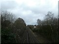
Looking north-east along the railway track from Tilmore Bridge
Image: © Basher Eyre
Taken: 15 Feb 2022
0.03 miles
5
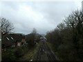
Looking south-west along the railway track from Tilmore Bridge
Image: © Basher Eyre
Taken: 15 Feb 2022
0.03 miles
6
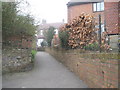
Alleyway from Osborne Road to Bannerman.
Taken looking up the alley.
Image: © Basher Eyre
Taken: 20 Feb 2008
0.03 miles
7
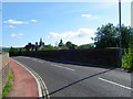
Bridge, Tilmore Road, Petersfield
There is an Ordnance Survey bench mark of the west parapet of the bridge.
Image: © Maigheach-gheal
Taken: 31 Aug 2010
0.04 miles
8
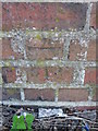
Bench Mark, Tilmore Road
The bench mark is to be found on the east face of the bridge's west parapet. For a view of the bridge http://www.geograph.org.uk/photo/2052645 and for more information on the cut mark http://www.bench-marks.org.uk/bm35444
A bench mark is an Ordnance Survey arrowhead sign found on walls, bridges, churches and specially erected triangulation pillars where the altitude above sea-level has been accurately measured by surveyors. The arrowhead points to a horizontal line above it which marks the exact altitude.
With rivets and pivots there is no datum (horizontal line) cut, the pointed-to horizontal surface defining the datum height.
Image: © Maigheach-gheal
Taken: 31 Aug 2010
0.04 miles