IMAGES TAKEN NEAR TO
Penns Road, PETERSFIELD, GU32 2EW
Introduction
This page details the photographs taken nearby to Penns Road, GU32 2EW by members of the Geograph project.
The Geograph project started in 2005 with the aim of publishing, organising and preserving representative images for every square kilometre of Great Britain, Ireland and the Isle of Man.

There are currently over 7.5m images from over14,400 individuals and you can help contribute to the project by visiting https://www.geograph.org.uk
Image Map
Images are licensed for reuse under creativecommons.org/licenses/by-sa/2.0
Notes
- Clicking on the map will re-center to the selected point.
- The higher the marker number, the further away the image location is from the centre of the postcode.
Image Listing (756 Images Found)
Images are licensed for reuse under creativecommons.org/licenses/by-sa/2.0
Image
Details
Distance
1
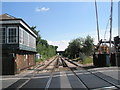
Looking towards Liss from level crossing
Image: © Basher Eyre
Taken: 7 Jun 2008
0.00 miles
2
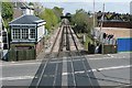
Petersfield level crossing
Looking north from Petersfield station, across the level crossing and past the signal box towards a bridge carrying Tilmore Road. To the right there used to be the platform for the line towards Midhurst, that veered right just beyond the trees. The line closed in the 1960s.
Although the crossing now has barrier gates, it is still operated from the signal box, due to the volume of traffic on the road. I remember being here in the early 1970s, when the gates were full gates, and the Milk Race (cycling Tour of Britain) was coming through. About six cyclists were a few hundred metres ahead; they were let across the crossing then the gates were closed before the remaining cyclists got there. Oops!
Image: © Graham Horn
Taken: 13 Apr 2009
0.02 miles
4
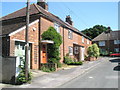
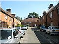
Houses opposite the factories in Penns Road
Image: © Basher Eyre
Taken: 7 Jun 2008
0.03 miles
5
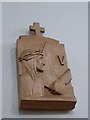
St Laurence's RC Church, Petersfield: Fifth Station of the Cross
Also see https://en.wikipedia.org/wiki/Stations_of_the_Cross
Image: © Basher Eyre
Taken: 10 Sep 2016
0.04 miles
6
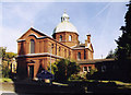
St Lawrence, Petersfield
Grade 2 listed building erected in 1890.
Image: © Michael FORD
Taken: Unknown
0.04 miles
7
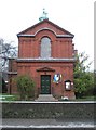
Main entrance to St Laurence's
Taken in Station Road.
Image: © Basher Eyre
Taken: 23 Dec 2009
0.04 miles
9
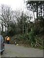
Storm Eunice: the clear up begins
The Great Storms of 1987 and 1990 it was not, but here in Tilmore Road a fallen tree did need to be removed....
Image: © Basher Eyre
Taken: 19 Feb 2022
0.04 miles