IMAGES TAKEN NEAR TO
Farnham Road, PETERSFIELD, GU32 2AW
Introduction
This page details the photographs taken nearby to Farnham Road, GU32 2AW by members of the Geograph project.
The Geograph project started in 2005 with the aim of publishing, organising and preserving representative images for every square kilometre of Great Britain, Ireland and the Isle of Man.

There are currently over 7.5m images from over14,400 individuals and you can help contribute to the project by visiting https://www.geograph.org.uk
Image Map
Images are licensed for reuse under creativecommons.org/licenses/by-sa/2.0
Notes
- Clicking on the map will re-center to the selected point.
- The higher the marker number, the further away the image location is from the centre of the postcode.
Image Listing (172 Images Found)
Images are licensed for reuse under creativecommons.org/licenses/by-sa/2.0
Image
Details
Distance
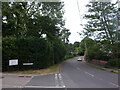
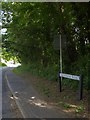
1
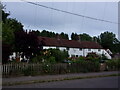
Looking across Farnham Road towards Tanyard Cottages
Image: © Basher Eyre
Taken: 28 Jun 2022
0.01 miles
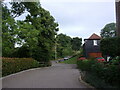
2
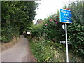
Looking from Farnham Road into Mill Lane
Image: © Basher Eyre
Taken: 28 Jun 2022
0.02 miles
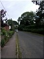
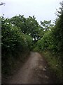
5
Junction of Tanners Reach and Farnham Road
Image: © Basher Eyre
Taken: 28 Jun 2022
0.04 miles
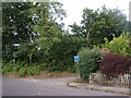
6
Looking down Tanners Reach towards Farnham Road
Image: © Basher Eyre
Taken: 28 Jun 2022
0.05 miles
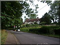
10
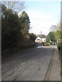
Looking along the Farnham Road towards the fork with School Lane
Image: © Basher Eyre
Taken: 7 Mar 2009
0.07 miles