IMAGES TAKEN NEAR TO
Langrish, PETERSFIELD, GU32 1RN
Introduction
This page details the photographs taken nearby to GU32 1RN by members of the Geograph project.
The Geograph project started in 2005 with the aim of publishing, organising and preserving representative images for every square kilometre of Great Britain, Ireland and the Isle of Man.

There are currently over 7.5m images from over14,400 individuals and you can help contribute to the project by visiting https://www.geograph.org.uk
Image Map
Images are licensed for reuse under creativecommons.org/licenses/by-sa/2.0
Notes
- Clicking on the map will re-center to the selected point.
- The higher the marker number, the further away the image location is from the centre of the postcode.
Image Listing (27 Images Found)
Images are licensed for reuse under creativecommons.org/licenses/by-sa/2.0
Image
Details
Distance
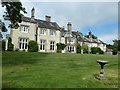
2
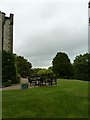
Front of Langrish House
Now a hotel, but has vaults built by the Royalists during the civil war.
Image: © Basher Eyre
Taken: 28 May 2011
0.01 miles

5
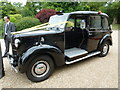
1957 London taxi outside Langrish House
Image: © Basher Eyre
Taken: 28 May 2011
0.02 miles
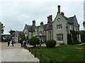
10
Rear of Langrish House
Now a hotel, but has vaults built by the Royalists during the civil war.
Image: © Basher Eyre
Taken: 29 May 2011
0.05 miles