IMAGES TAKEN NEAR TO
Temple Lane, PETERSFIELD, GU32 1NU
Introduction
This page details the photographs taken nearby to Temple Lane, GU32 1NU by members of the Geograph project.
The Geograph project started in 2005 with the aim of publishing, organising and preserving representative images for every square kilometre of Great Britain, Ireland and the Isle of Man.

There are currently over 7.5m images from over14,400 individuals and you can help contribute to the project by visiting https://www.geograph.org.uk
Image Map
Images are licensed for reuse under creativecommons.org/licenses/by-sa/2.0
Notes
- Clicking on the map will re-center to the selected point.
- The higher the marker number, the further away the image location is from the centre of the postcode.
Image Listing (332 Images Found)
Images are licensed for reuse under creativecommons.org/licenses/by-sa/2.0
Image
Details
Distance
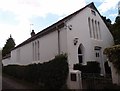
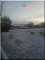
1
Anvil close on a sunny autumn morning
Image: © Liam mansfield
Taken: 18 Oct 2022
0.05 miles
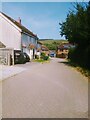
2
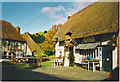
East Meon Post Office.
This thatched building also houses the "Riverside Shop". Beyond the thatched roofs is Park Hill.
Image: © Colin Smith
Taken: Unknown
0.06 miles
3
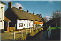
Riverside Thatched Cottages in East Meon.
The Meon, in its early stages, flows through the middle of the High Street of this village.
Image: © Colin Smith
Taken: Unknown
0.06 miles
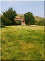
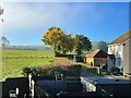
7
Looking down Glenthorne Meadow towards the High Street
Image: © Basher Eyre
Taken: 20 Sep 2009
0.07 miles
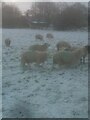
9
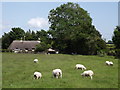
Belmont Farm, East Meon
Sheep on a chalk grassland field at the edge of the downland village.
Image: © Colin Smith
Taken: 19 Jun 2012
0.08 miles