IMAGES TAKEN NEAR TO
East Meon, PETERSFIELD, GU32 1HT
Introduction
This page details the photographs taken nearby to GU32 1HT by members of the Geograph project.
The Geograph project started in 2005 with the aim of publishing, organising and preserving representative images for every square kilometre of Great Britain, Ireland and the Isle of Man.

There are currently over 7.5m images from over14,400 individuals and you can help contribute to the project by visiting https://www.geograph.org.uk
Image Map
Images are licensed for reuse under creativecommons.org/licenses/by-sa/2.0
Notes
- Clicking on the map will re-center to the selected point.
- The higher the marker number, the further away the image location is from the centre of the postcode.
Image Listing (7 Images Found)
Images are licensed for reuse under creativecommons.org/licenses/by-sa/2.0
Image
Details
Distance
2
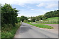
Road east of East Meon
Looking towards East Meon on the road from Langrish. Unusually for a rural road, bus stop flags are provided throughout, although this one covers both directions.
Image: © Stephen McKay
Taken: 28 Nov 2017
0.09 miles
3
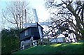
Sculptures at Pidham Farm
Just a few of the interesting sculptures to be found a Pidham Farm.
Image: © Maigheach-gheal
Taken: 10 Feb 2008
0.11 miles
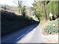
5
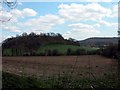
Farmland at the foot of Barrow Hill
Image: © Martyn Pattison
Taken: 11 Apr 2005
0.14 miles
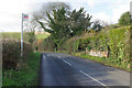
6
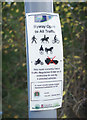
Byway Open to All Traffic
The byway leads to Frogmore but, as this notice makes clear, four-wheeled vehicles are currently restricted from using it. In fact, it is only really passable on foot and how a horse and two-wheeled cart would get on is anybody's guess - see Image
Image: © Stephen McKay
Taken: 28 Nov 2017
0.16 miles
