IMAGES TAKEN NEAR TO
Northfields, GU32 1FA
Introduction
This page details the photographs taken nearby to Northfields, GU32 1FA by members of the Geograph project.
The Geograph project started in 2005 with the aim of publishing, organising and preserving representative images for every square kilometre of Great Britain, Ireland and the Isle of Man.

There are currently over 7.5m images from over14,400 individuals and you can help contribute to the project by visiting https://www.geograph.org.uk
Image Map
Images are licensed for reuse under creativecommons.org/licenses/by-sa/2.0
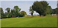
Notes
- Clicking on the map will re-center to the selected point.
- The higher the marker number, the further away the image location is from the centre of the postcode.
Image Listing (166 Images Found)
Images are licensed for reuse under creativecommons.org/licenses/by-sa/2.0
Image
Details
Distance
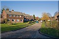
2
Looking into Long Priors
See http://www.geograph.org.uk/photo/631280 for a picture from 2007.
Image: © Shazz
Taken: 5 Jun 2014
0.07 miles
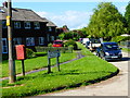
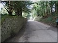
3
Long Priors, West Meon
A cul de sac with housing off Church Lane.
Image: © Peter Facey
Taken: 11 Dec 2007
0.07 miles
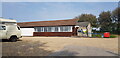
5
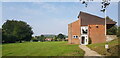
Sports Pavilion at West Meon Recreation Ground
Image: © Paul Collins
Taken: 5 Sep 2021
0.09 miles
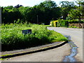
6
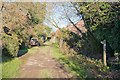
Footpath leaves Church Lane at Floud Cottages, West Meon
Image: © Peter Facey
Taken: 11 Dec 2007
0.10 miles
8
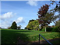
An autumnal recreation ground at West Meon
Image: © Basher Eyre
Taken: 17 Oct 2013
0.12 miles
10
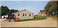
West Meon Village Hall
A sports pavilion can be seen to the right of the hall.
Image: © Paul Collins
Taken: 5 Sep 2021
0.12 miles