IMAGES TAKEN NEAR TO
Old Portsmouth Road, GUILDFORD, GU3 1LZ
Introduction
This page details the photographs taken nearby to Old Portsmouth Road, GU3 1LZ by members of the Geograph project.
The Geograph project started in 2005 with the aim of publishing, organising and preserving representative images for every square kilometre of Great Britain, Ireland and the Isle of Man.

There are currently over 7.5m images from over14,400 individuals and you can help contribute to the project by visiting https://www.geograph.org.uk
Image Map (Loading...)


Getting Data...Please wait
Leaflet Map data © OpenStreetMap
Images are licensed for reuse under creativecommons.org/licenses/by-sa/2.0
Notes
- Clicking on the map will re-center to the selected point.
- The higher the marker number, the further away the image location is from the centre of the postcode.
Image Listing (51 Images Found)
Images are licensed for reuse under creativecommons.org/licenses/by-sa/2.0
Image
Details
Distance
1
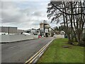
Hanson Ready Mix concrete works
Hanson company site based in the Riverway Estate.
Image: © James Emmans
Taken: 12 Mar 2021
0.04 miles
2
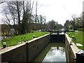
Unstead Lock
On the River Wey Navigation en route from Guildford to Godalming in Surrey. I am looking towards Godalming.
Image: © Carroll Pierce
Taken: 21 Mar 2014
0.05 miles
4
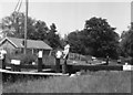
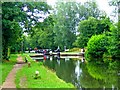
Peasmarsh - Unstead Lock
Narrowboat "Dot" passing through a lock on the River Wey Navigation between Farncombe and Guildford.
www.weyriver.co.uk
Image: © Colin Smith
Taken: 31 May 2024
0.06 miles
5
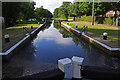
Unstead Lock, River Wey Navigation
This is the penultimate lock before the end of the navigable river at Godalming Wharf.
Image: © Ian Taylor
Taken: 18 Jul 2010
0.06 miles
6
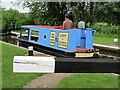
Unstead Lock filled with water, Godalming Navigation
A boat has just left the lock. The gates are open as another boat going in the opposite direction is about to enter.Image
Image: © L S Wilson
Taken: 26 Jul 2009
0.06 miles
7
Godalming Navigation and Unstead Lock
The four mile long Godalming Navigation is a continuation of the Wey Navigation. Both are owned and managed by the National Trust.
Image: © L S Wilson
Taken: 26 Jul 2009
0.06 miles
8
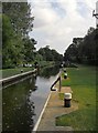
Unstead Lock, Godalming Navigation
'Opened in 1764 next to the site of Unstead Mill' - according to National Trust board at the site.
To the south of the lock there is a long straight stretch of the Navigation, while the old course of the River Wey meanders through the meadows of the flood-plain, a little further east.
Image: © Stefan Czapski
Taken: 31 Jul 2014
0.06 miles
9
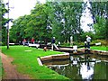
Unstead Lock, Godalming Navigation
The top of a narrow boat, in the lock, can just be glimpsed in this view. The lock is being filled with water to bring it to the level of the pound (stretch of canal between locks) seen in the foreground. This will enable the boat to enter the pound from the lock. Image
Image: © L S Wilson
Taken: 26 Jul 2009
0.06 miles
10
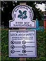
Lock area safety notice at Unstead Lock, Goldaming Navigation
The lock's owners, the National Trust, have placed this notice at the side of the footpath, opposite the lock. The River Wey Navigations refer to the Wey Navigation and the Godalming Navigation. There is a lot of confusion between the two, but Unstead Lock is on the Godalming Navigation, which continues to Guildford, where it becomes the Wey Navigation. This section does not even use the River Wey, because it was too winding, so a new channel was cut. Image
Image: © L S Wilson
Taken: 26 Jul 2009
0.06 miles