IMAGES TAKEN NEAR TO
Littleton Lane, GUILDFORD, GU3 1HR
Introduction
This page details the photographs taken nearby to Littleton Lane, GU3 1HR by members of the Geograph project.
The Geograph project started in 2005 with the aim of publishing, organising and preserving representative images for every square kilometre of Great Britain, Ireland and the Isle of Man.

There are currently over 7.5m images from over14,400 individuals and you can help contribute to the project by visiting https://www.geograph.org.uk
Image Map (Loading...)


Getting Data...Please wait
Leaflet Map data © OpenStreetMap
Images are licensed for reuse under creativecommons.org/licenses/by-sa/2.0
Notes
- Clicking on the map will re-center to the selected point.
- The higher the marker number, the further away the image location is from the centre of the postcode.
Image Listing (10 Images Found)
Images are licensed for reuse under creativecommons.org/licenses/by-sa/2.0
Image
Details
Distance
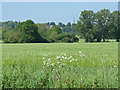
1
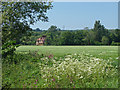
Brickfields Farm
Looking across the fields to the west of Peasmarsh towards Brickfields farm and the Mount Browne police headquarters mast on the horizon.
Image: © Alan Hunt
Taken: 18 May 2014
0.05 miles
2
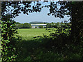
Hole in the hedge
The view looking towards the industrial estate near Peasmarsh from the footpath past Brickfields Farm. The hill in the far background is Chinthurst Hill near Wonersh.
Image: © Alan Hunt
Taken: 18 May 2014
0.07 miles
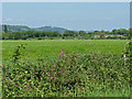
3
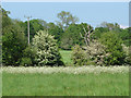
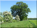
Fields in the springtime
Looking across the fields near Brickfields Farm in mid May with the hawthorn in full bloom and the fields full of cow parsley.
Image: © Alan Hunt
Taken: 18 May 2014
0.09 miles
4
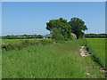
Fieldscape near Peasmarsh
The footpath follows the field boundary to the west of the railway line near Peasmarsh.
Image: © Alan Hunt
Taken: 18 May 2014
0.13 miles
5
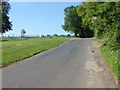
Stakescorner Road, Littleton.
The back road into Loseley House - the tradesman's entrance!
Image: © Colin Smith
Taken: Unknown
0.16 miles
6
Hawthorn and oak
A fine hedgerow oak and hawthorn bushes in full bloom along a field boundary west of Peasmarsh.
Image: © Alan Hunt
Taken: 18 May 2014
0.16 miles
7
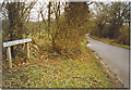
Private track opposite the entrance to Losely Park
Image: © Basher Eyre
Taken: 2 Feb 2017
0.20 miles
8
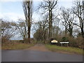
Stakescorner Road
Looking north along Stakescorner Road with an entrance to Loseley Park on the left
Image: © Alan Hunt
Taken: 18 May 2014
0.21 miles
9
View towards Mount Browne
Looking across the fields to the west of Peasmarsh with the Mount Browne police headquarters in the trees on the horizon.
Image: © Alan Hunt
Taken: 18 May 2014
0.23 miles
10
Fields near Peasmarsh
Red Campion in the hedge between two fields. In the middle distance is the brick bridge carrying the A3100 over the railway and on the horizon Chantries Hill to the southwest of Guildford.
Image: © Alan Hunt
Taken: 18 May 2014
0.24 miles