IMAGES TAKEN NEAR TO
Hogs Back, GUILDFORD, GU3 1DF
Introduction
This page details the photographs taken nearby to Hogs Back, GU3 1DF by members of the Geograph project.
The Geograph project started in 2005 with the aim of publishing, organising and preserving representative images for every square kilometre of Great Britain, Ireland and the Isle of Man.

There are currently over 7.5m images from over14,400 individuals and you can help contribute to the project by visiting https://www.geograph.org.uk
Image Map (Loading...)


Getting Data...Please wait
Leaflet Map data © OpenStreetMap
Images are licensed for reuse under creativecommons.org/licenses/by-sa/2.0
Notes
- Clicking on the map will re-center to the selected point.
- The higher the marker number, the further away the image location is from the centre of the postcode.
Image Listing (5 Images Found)
Images are licensed for reuse under creativecommons.org/licenses/by-sa/2.0
Image
Details
Distance
1
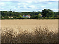
Blackwell Farm
Looking across the dried rape crop towards Blackwell Farm with the telecommunication masts on the Hog's Back in the distance
Image: © Alan Hunt
Taken: 2 Sep 2013
0.05 miles
2
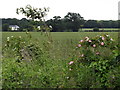
Blackwell Farm
Wild roses in the foreground; a wheat field between the bridleway and the farm.
Image: © Colin Smith
Taken: 20 Jun 2012
0.08 miles
3
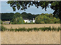
Blackwell Farm
The buildings of Blackwell Farm from the footpath from Woodstreet to the Hog's Back.
Image: © Alan Hunt
Taken: 2 Sep 2013
0.09 miles

5
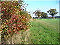
West of Blackwell Farm
Flowering hedgerow and large pastures below the northern slope of the Hog's Back.
Image: © Colin Smith
Taken: 3 Nov 2007
0.25 miles