IMAGES TAKEN NEAR TO
Hogs Back, GUILDFORD, GU3 1AA
Introduction
This page details the photographs taken nearby to Hogs Back, GU3 1AA by members of the Geograph project.
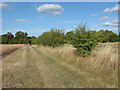
The Geograph project started in 2005 with the aim of publishing, organising and preserving representative images for every square kilometre of Great Britain, Ireland and the Isle of Man.

There are currently over 7.5m images from over14,400 individuals and you can help contribute to the project by visiting https://www.geograph.org.uk
Image Map
Images are licensed for reuse under creativecommons.org/licenses/by-sa/2.0
Notes
- Clicking on the map will re-center to the selected point.
- The higher the marker number, the further away the image location is from the centre of the postcode.
Image Listing (14 Images Found)
Images are licensed for reuse under creativecommons.org/licenses/by-sa/2.0
Image
Details
Distance
1
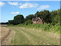
Cottage in the woods
Chalkpit Cottage on the edge of Chalkpit Wood just below the Hog's Back ridge.
Image: © Alan Hunt
Taken: 2 Sep 2013
0.02 miles
2
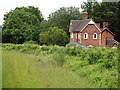
Bridleway by Chalkpit Wood
Downland grassy track passing a house and woodland on the northern slope of the Hog's Back.
Image: © Colin Smith
Taken: 20 Jun 2012
0.02 miles
3
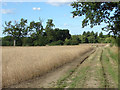
Footpath near the Hog's Back
Looking north along the footpath to Woodstreet with Misley Copse in the background.
Image: © Alan Hunt
Taken: 2 Sep 2013
0.04 miles
4
Chalkpit Wood
Wide grassy bridleway passing between a patch of deciduous woodland and an oilseed rape field.
Image: © Colin Smith
Taken: 20 Jun 2012
0.07 miles
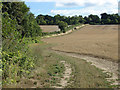
5
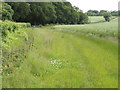
Field boundary
A scrubby field boundary along the footpath from Woodstreet to the Hog's Back.
Image: © Alan Hunt
Taken: 2 Sep 2013
0.08 miles
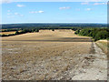
6
View from The Hog's Back
Looking north from the Hog's Back over farmland.
Image: © Paul E Smith
Taken: 15 May 2010
0.10 miles

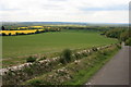
8
View from the Hog's Back
The view north from the top of the Hog's Back looking across the large fields on the backslope towards the Ash and Pirbright army ranges and beyond. Chalkpit Wood is on the right at the bottom of the slope.
Image: © Alan Hunt
Taken: 2 Sep 2013
0.12 miles
9
The Hog's Back ridge
The northern slope of the Hog's Back ridge from near Chalkpit Wood.
Image: © Alan Hunt
Taken: 2 Sep 2013
0.14 miles
10

Field viewed from corner
The footpath is in the wood behind the camera but this was impassable.
Image: © Shazz
Taken: 29 Jun 2014
0.16 miles