IMAGES TAKEN NEAR TO
Glebe Road, PETERSFIELD, GU31 5SB
Introduction
This page details the photographs taken nearby to Glebe Road, GU31 5SB by members of the Geograph project.
The Geograph project started in 2005 with the aim of publishing, organising and preserving representative images for every square kilometre of Great Britain, Ireland and the Isle of Man.

There are currently over 7.5m images from over14,400 individuals and you can help contribute to the project by visiting https://www.geograph.org.uk
Image Map
Images are licensed for reuse under creativecommons.org/licenses/by-sa/2.0
Notes
- Clicking on the map will re-center to the selected point.
- The higher the marker number, the further away the image location is from the centre of the postcode.
Image Listing (66 Images Found)
Images are licensed for reuse under creativecommons.org/licenses/by-sa/2.0
Image
Details
Distance
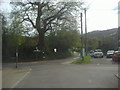
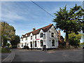
2
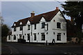
Village Inn, Buriton
For once, a village pub that has been closed but come back to life. The Village Inn has recently re-opened after being refurbished.
Image: © Robert Eva
Taken: 14 Jan 2017
0.06 miles
4
Petersfield Means Business (177)
The Village Inn, which was called The Maple in my (long past) drinking days!
Image: © Basher Eyre
Taken: 27 Oct 2019
0.08 miles
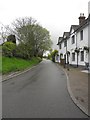
5
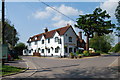
The Maple Inn, Buriton
Situated at the junction of Greenway Lane with Petersfield Road. http://www.buriton.info/maple_inn
Image: © Barry Shimmon
Taken: 23 May 2012
0.08 miles