IMAGES TAKEN NEAR TO
Ditcham, PETERSFIELD, GU31 5RN
Introduction
This page details the photographs taken nearby to GU31 5RN by members of the Geograph project.
The Geograph project started in 2005 with the aim of publishing, organising and preserving representative images for every square kilometre of Great Britain, Ireland and the Isle of Man.

There are currently over 7.5m images from over14,400 individuals and you can help contribute to the project by visiting https://www.geograph.org.uk
Image Map (Loading...)


Getting Data...Please wait
Leaflet Map data © OpenStreetMap
Images are licensed for reuse under creativecommons.org/licenses/by-sa/2.0
Notes
- Clicking on the map will re-center to the selected point.
- The higher the marker number, the further away the image location is from the centre of the postcode.
Image Listing (5 Images Found)
Images are licensed for reuse under creativecommons.org/licenses/by-sa/2.0
Image
Details
Distance
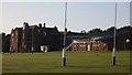
2
Ditcham Park School
According to its sign, a 'Co-educational independent day school Juniors 4 - 11 Seniors 11 - 16'.
Image: © Robin Webster
Taken: 4 Nov 2013
0.06 miles
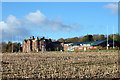
4
Ditcham Park School and grounds
A private school outside Petersfield, on the south side of the South Downs
Image: © Keith Rose
Taken: 11 Jun 2006
0.12 miles
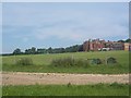
5
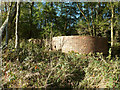
Old sewage works?
This round brick structure seems to have no roof, and has what looks like a sewer pipe entering it from the direction of Ditcham House (now a school). Rather oddly, it is on high ground above Downley Bottom. Although marked on later 20th century maps, they give no clue what it is.
Image: © Robin Webster
Taken: 4 Nov 2013
0.24 miles