IMAGES TAKEN NEAR TO
Chithurst, PETERSFIELD, GU31 5EZ
Introduction
This page details the photographs taken nearby to GU31 5EZ by members of the Geograph project.
The Geograph project started in 2005 with the aim of publishing, organising and preserving representative images for every square kilometre of Great Britain, Ireland and the Isle of Man.

There are currently over 7.5m images from over14,400 individuals and you can help contribute to the project by visiting https://www.geograph.org.uk
Image Map
Images are licensed for reuse under creativecommons.org/licenses/by-sa/2.0
Notes
- Clicking on the map will re-center to the selected point.
- The higher the marker number, the further away the image location is from the centre of the postcode.
Image Listing (10 Images Found)
Images are licensed for reuse under creativecommons.org/licenses/by-sa/2.0
Image
Details
Distance
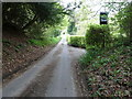
1
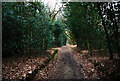
Green Lane (track) off Chithurst Lane
The restricted Byway runs to Borden.
Image: © Dave Spicer
Taken: 13 May 2012
0.08 miles
3

House near Holm Wood
The sun is quite low and the light is reflected in the windows.
Image: © Shazz
Taken: 2 Mar 2009
0.09 miles
5
Chithurst Lane passing Malt House
At first glance I thought it was a pub sign.
Image: © Dave Spicer
Taken: 13 May 2012
0.14 miles
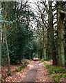
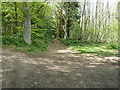
7
Chithurst Lane, by Holm Wood
A sunny April walk along this lane.
Image: © Jacko
Taken: 2 Apr 2009
0.17 miles
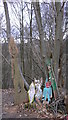
8
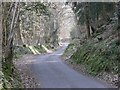
A quiet lane winds up a hillside
This is a continuation of Cook's Pond Road, which runs from near Milland to meet Hammer Lane, near Chithurst.
Image: © Jacko
Taken: 2 Apr 2009
0.17 miles
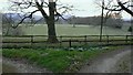
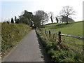
9
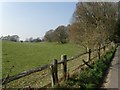
Wood and fields from the lane
Looking west-north-west from Cook's Pond Road, up a small valley with Holm Wood to the right.
Image: © Jacko
Taken: 2 Apr 2009
0.21 miles