IMAGES TAKEN NEAR TO
Rogate, PETERSFIELD, GU31 5DR
Introduction
This page details the photographs taken nearby to GU31 5DR by members of the Geograph project.
The Geograph project started in 2005 with the aim of publishing, organising and preserving representative images for every square kilometre of Great Britain, Ireland and the Isle of Man.

There are currently over 7.5m images from over14,400 individuals and you can help contribute to the project by visiting https://www.geograph.org.uk
Image Map
Images are licensed for reuse under creativecommons.org/licenses/by-sa/2.0
Notes
- Clicking on the map will re-center to the selected point.
- The higher the marker number, the further away the image location is from the centre of the postcode.
Image Listing (12 Images Found)
Images are licensed for reuse under creativecommons.org/licenses/by-sa/2.0
Image
Details
Distance
1
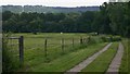
Driveway from Canhouse Lane to Combeland Farm
The firebreak on Fyning Common is visible at the top left of the picture.
Image: © Shazz
Taken: 16 Jun 2009
0.03 miles
2
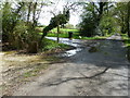
Bridleway to Combeland Farm
Off Canhouse Lane.
Image: © Dave Spicer
Taken: 30 Apr 2012
0.07 miles
3
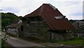
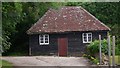
Haybarn which has seen better days
This is at Combeland Farm between Rake and Milland.
Image: © Shazz
Taken: 16 Jun 2009
0.10 miles
6
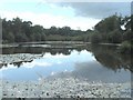
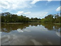
Combe Pond, Rake, West Sussex
A public footpath off Canhouse Lane leads to the tranquil Combe Pond completely surrounded by woodland. The pond is managed by the Fyning Hill Estate.
Image: © Anthony Brunning
Taken: 16 Sep 2005
0.15 miles
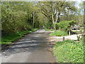
10
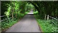
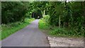
Looking south on Canhouse Lane
Here the lane goes over a small stream. A footpath is signed to the left.
Image: © Shazz
Taken: 16 Jun 2009
0.19 miles