IMAGES TAKEN NEAR TO
Smithfield, PETERSFIELD, GU31 5BD
Introduction
This page details the photographs taken nearby to Smithfield, GU31 5BD by members of the Geograph project.
The Geograph project started in 2005 with the aim of publishing, organising and preserving representative images for every square kilometre of Great Britain, Ireland and the Isle of Man.

There are currently over 7.5m images from over14,400 individuals and you can help contribute to the project by visiting https://www.geograph.org.uk
Image Map
Images are licensed for reuse under creativecommons.org/licenses/by-sa/2.0
Notes
- Clicking on the map will re-center to the selected point.
- The higher the marker number, the further away the image location is from the centre of the postcode.
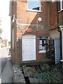
Image Listing (339 Images Found)
Images are licensed for reuse under creativecommons.org/licenses/by-sa/2.0
Image
Details
Distance
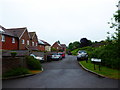
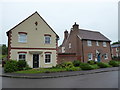
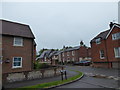
1
Junction of Smithfield with the road to Turkey Island
Image: © Basher Eyre
Taken: 29 May 2017
0.01 miles
3
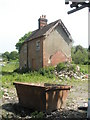
Sid's house still standing
He was as one villager put it "the very last of the South Harting characters". An old style blacksmith, he died two years ago. His forge has gone and presumably the house will in time be demolished and the plot on the Elsted Road sold.
Image: © Basher Eyre
Taken: 25 May 2009
0.01 miles
4
Smithfield
Named after local legend Sid Smith RIP
Image: © Basher Eyre
Taken: 29 May 2017
0.01 miles
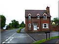
6
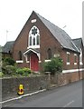
Shaxson Memorial Hall on the Elsted Road
Formerly a Primitive Methodist Church
Image: © Basher Eyre
Taken: 25 May 2009
0.03 miles
7
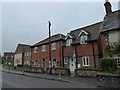
Where once stood one, now stand 12
A real Harting character, Sid Smith's forge was here http://www.geograph.org.uk/photo/1319367 but after his death planning permission was given for 12 dwellings. Number One is Forge Cottage, and the whole development named Smithfield!
Image: © Basher Eyre
Taken: 29 May 2017
0.03 miles
8
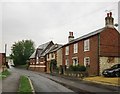
South Harting: clunch and rat-trap bond
I stopped to look at these buildings because of the exposed chalk (clunch) walling. Looking more closely, I noticed that the house nearest the camera is built of bricks laid on edge - penny-pinching 'rat-trap bond'. It puzzles me that after scrimping on bricks, the builder tried to make up for it by fitting quite a grand door-case (as Pevsner would call it). Ostentation at the price of neglecting the basics. There's a tabloid phrase for that sort of thing - and it has to do with fur coats.
Image: © Stefan Czapski
Taken: 11 Aug 2015
0.03 miles
9
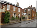
South Harting: rat-trap bond
The three-bay house with the fancy door-case was built using the notorious 'rat-trap bond' - lay bricks on their edges, and you don't need so many of them. Despite skimping on materials, the brick-layer has attempted something like classic Flemish bond - a neat pattern, with red stretchers and blue headers alternating throughout.
Edging into the left-hand margin of the picture is a cottage built largely of 'clunch' - substantial blocks of chalk. The building is either recent or much renewed - either way, it's good to see that traditional local materials were used. There is more clunch to be seen in a free-standing wall, just beyond the open parking bay. And a photo taken from the opposite direction reveals yet more . . . http://www.geograph.org.uk/photo/4616833
Image: © Stefan Czapski
Taken: 11 Aug 2015
0.03 miles
10
Looking from Smithfield towards the former Primitive Methodist Church
Also see http://www.myprimitivemethodists.org.uk/page/south_harting_primitive_methodist_chapel
Image: © Basher Eyre
Taken: 29 May 2017
0.03 miles