IMAGES TAKEN NEAR TO
PETERSFIELD, GU31 5AU
Introduction
This page details the photographs taken nearby to GU31 5AU by members of the Geograph project.
The Geograph project started in 2005 with the aim of publishing, organising and preserving representative images for every square kilometre of Great Britain, Ireland and the Isle of Man.

There are currently over 7.5m images from over14,400 individuals and you can help contribute to the project by visiting https://www.geograph.org.uk
Image Map
Images are licensed for reuse under creativecommons.org/licenses/by-sa/2.0
Notes
- Clicking on the map will re-center to the selected point.
- The higher the marker number, the further away the image location is from the centre of the postcode.
Image Listing (13 Images Found)
Images are licensed for reuse under creativecommons.org/licenses/by-sa/2.0
Image
Details
Distance
2
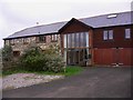
Cottage at Durleighmarsh
This is in West Sussex.
Image: © Shazz
Taken: 21 Nov 2010
0.01 miles
3
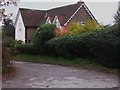
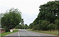
Access road on the A272
This road is in West Sussex and serves a group of houses. It may have once been part of the original road between Rogate and Petersfield. The A272 is in the foreground.
Image: © Shazz
Taken: 21 Nov 2010
0.09 miles
4
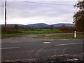
Field entrance on the A272, Durleighmarsh
Image: © David Howard
Taken: 18 Aug 2018
0.10 miles
6
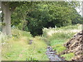
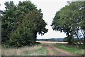
Track between fields going south to the A272
The track appears disused to the north (see Image] ). Here it gives access to a midden. This is in West Sussex.
Image: © Shazz
Taken: 27 Jul 2015
0.18 miles
7
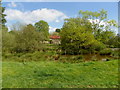
Durford Abbey Farm and ponds
Parts of the farm buildings here were originally part of the Abbey.
Image: © Martyn Pattison
Taken: 26 Apr 2020
0.19 miles
8
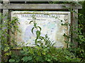
Information panel at Maiden Marsh layby
This rather neglected notice could not be viewed closely due to a large and dingy puddle not suitable for plimsolls. This is in West Sussex.
Image: © Shazz
Taken: 27 Jul 2015
0.20 miles
10
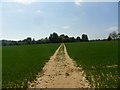
Well marked footpath on The Serpernt's Trail
Image: © Martyn Pattison
Taken: 26 Apr 2020
0.23 miles