IMAGES TAKEN NEAR TO
Henwood Down, PETERSFIELD, GU31 4PP
Introduction
This page details the photographs taken nearby to Henwood Down, GU31 4PP by members of the Geograph project.
The Geograph project started in 2005 with the aim of publishing, organising and preserving representative images for every square kilometre of Great Britain, Ireland and the Isle of Man.

There are currently over 7.5m images from over14,400 individuals and you can help contribute to the project by visiting https://www.geograph.org.uk
Image Map
Images are licensed for reuse under creativecommons.org/licenses/by-sa/2.0
Notes
- Clicking on the map will re-center to the selected point.
- The higher the marker number, the further away the image location is from the centre of the postcode.
Image Listing (253 Images Found)
Images are licensed for reuse under creativecommons.org/licenses/by-sa/2.0
Image
Details
Distance
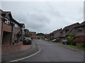
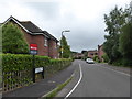
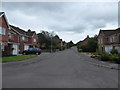
2
Junction of Marden Way and Henwood Down
Image: © Basher Eyre
Taken: 26 Jun 2022
0.02 miles
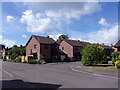
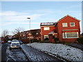
4
Herne Farm Co-Op
Taken from Moggs Mead.
Image: © Basher Eyre
Taken: 18 Feb 2008
0.02 miles
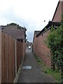
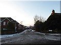
7
14: S'no joke, ice a-stayin' in!
Moggs Mead
Image: © Basher Eyre
Taken: 2 Feb 2019
0.03 miles
8
13: S'no joke, ice a-stayin' in!
Marden Way
Image: © Basher Eyre
Taken: 2 Feb 2019
0.03 miles
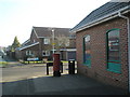
9
Herne Farm: sarf of the river (36)
Looking along Marden Way towards River Way
(with Moggs Mead in the distance)
Image: © Basher Eyre
Taken: 2 Aug 2017
0.03 miles
