IMAGES TAKEN NEAR TO
Buriton, PETERSFIELD, GU31 4NW
Introduction
This page details the photographs taken nearby to GU31 4NW by members of the Geograph project.
The Geograph project started in 2005 with the aim of publishing, organising and preserving representative images for every square kilometre of Great Britain, Ireland and the Isle of Man.

There are currently over 7.5m images from over14,400 individuals and you can help contribute to the project by visiting https://www.geograph.org.uk
Image Map
Images are licensed for reuse under creativecommons.org/licenses/by-sa/2.0
Notes
- Clicking on the map will re-center to the selected point.
- The higher the marker number, the further away the image location is from the centre of the postcode.
Image Listing (11 Images Found)
Images are licensed for reuse under creativecommons.org/licenses/by-sa/2.0
Image
Details
Distance
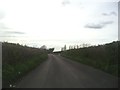
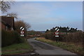
1
Petersfield Road between Petersfield and Buriton
Image: © David Howard
Taken: 30 Apr 2012
0.07 miles
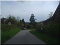
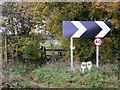
2
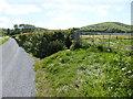
Shipwrights' Way 137
This footpath junction is passed on the way to Buriton.
Image: © Shazz
Taken: 14 May 2017
0.10 miles
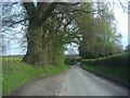
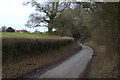
3
Petersfield Road with Black Hill Cottages
Image: © Robert Eva
Taken: 14 Jan 2017
0.12 miles
8
Footpath leading from bend in road near Buriton
Image: © Shazz
Taken: 21 Nov 2010
0.20 miles
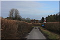
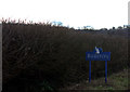
9
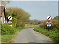
Petersfield road, no motor vehicles except for access
Petersfield Road has had no motor vehicle restrictions for several years, although the road is still open through to Petersfield.
Image: © Martyn Pattison
Taken: 12 Apr 2020
0.21 miles