IMAGES TAKEN NEAR TO
Griggs Green, LIPHOOK, GU30 7PD
Introduction
This page details the photographs taken nearby to Griggs Green, GU30 7PD by members of the Geograph project.
The Geograph project started in 2005 with the aim of publishing, organising and preserving representative images for every square kilometre of Great Britain, Ireland and the Isle of Man.

There are currently over 7.5m images from over14,400 individuals and you can help contribute to the project by visiting https://www.geograph.org.uk
Image Map (Loading...)


Getting Data...Please wait
Leaflet Map data © OpenStreetMap
Images are licensed for reuse under creativecommons.org/licenses/by-sa/2.0
Notes
- Clicking on the map will re-center to the selected point.
- The higher the marker number, the further away the image location is from the centre of the postcode.
Image Listing (5 Images Found)
Images are licensed for reuse under creativecommons.org/licenses/by-sa/2.0
Image
Details
Distance
2
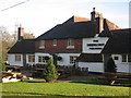
The Deers Hut, Griggs Green
The inn was built in the 1600s as a hunting lodge.
Image: © Maigheach-gheal
Taken: 4 Sep 2009
0.05 miles
3
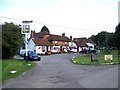
Shipwrights' Way 104
The walk turns right here close to the "Deers Hut" PH. See also http://www.geograph.org.uk/photo/1476575.
Image: © Shazz
Taken: 7 May 2017
0.06 miles
4
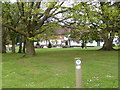
2016: a year on Geograph (Day 43)
The Deer Hut, Liphook
Image: © Basher Eyre
Taken: 12 Feb 2016
0.08 miles
5
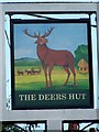
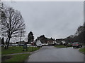
Sign for the Deers Hut
The area was known as a hunting area.
Image: © Maigheach-gheal
Taken: 4 Sep 2009
0.08 miles