IMAGES TAKEN NEAR TO
Hollycombe, LIPHOOK, GU30 7LR
Introduction
This page details the photographs taken nearby to Hollycombe, GU30 7LR by members of the Geograph project.
The Geograph project started in 2005 with the aim of publishing, organising and preserving representative images for every square kilometre of Great Britain, Ireland and the Isle of Man.

There are currently over 7.5m images from over14,400 individuals and you can help contribute to the project by visiting https://www.geograph.org.uk
Image Map (Loading...)


Getting Data...Please wait
Leaflet Map data © OpenStreetMap
Images are licensed for reuse under creativecommons.org/licenses/by-sa/2.0
Notes
- Clicking on the map will re-center to the selected point.
- The higher the marker number, the further away the image location is from the centre of the postcode.
Image Listing (40 Images Found)
Images are licensed for reuse under creativecommons.org/licenses/by-sa/2.0
Image
Details
Distance
2
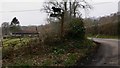
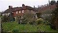
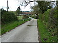
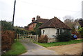
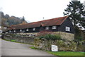
The way to Home Farm between Hollycombe and Wardley Marsh
Image: © Shazz
Taken: 12 Mar 2009
0.03 miles
10
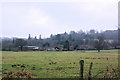
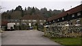
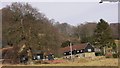
View towards Home Farm
The backdrop is Wardley Hanger.
Image: © Robin Webster
Taken: 19 Feb 2007
0.06 miles