IMAGES TAKEN NEAR TO
Cumberland Avenue, GUILDFORD, GU2 9YJ
Introduction
This page details the photographs taken nearby to Cumberland Avenue, GU2 9YJ by members of the Geograph project.
The Geograph project started in 2005 with the aim of publishing, organising and preserving representative images for every square kilometre of Great Britain, Ireland and the Isle of Man.

There are currently over 7.5m images from over14,400 individuals and you can help contribute to the project by visiting https://www.geograph.org.uk
Image Map
Images are licensed for reuse under creativecommons.org/licenses/by-sa/2.0
Notes
- Clicking on the map will re-center to the selected point.
- The higher the marker number, the further away the image location is from the centre of the postcode.
Image Listing (38 Images Found)
Images are licensed for reuse under creativecommons.org/licenses/by-sa/2.0
Image
Details
Distance

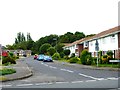
2

Path going south west from Oregano Way
The path is parallel with Cumberland Avenue.
Image: © Shazz
Taken: 29 Jun 2014
0.05 miles

5
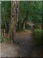
Whitmoor Common
Path running from the top of the embankment that runs alongside the Pitch Place rifle range.
Image: © Alan Hunt
Taken: 13 Sep 2011
0.12 miles


9
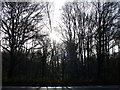
Salt Box Road Woodland
Bare deciduous trees separate the Grange Park housing estate from the road.
Image: © Colin Smith
Taken: 26 Dec 2007
0.13 miles
