IMAGES TAKEN NEAR TO
Regalfield Close, GUILDFORD, GU2 9YG
Introduction
This page details the photographs taken nearby to Regalfield Close, GU2 9YG by members of the Geograph project.
The Geograph project started in 2005 with the aim of publishing, organising and preserving representative images for every square kilometre of Great Britain, Ireland and the Isle of Man.

There are currently over 7.5m images from over14,400 individuals and you can help contribute to the project by visiting https://www.geograph.org.uk
Image Map
Images are licensed for reuse under creativecommons.org/licenses/by-sa/2.0
Notes
- Clicking on the map will re-center to the selected point.
- The higher the marker number, the further away the image location is from the centre of the postcode.
Image Listing (38 Images Found)
Images are licensed for reuse under creativecommons.org/licenses/by-sa/2.0
Image
Details
Distance
1
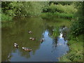
Chitty's Common
The pond at the north-west corner of Chitty's Common.
Image: © Alan Hunt
Taken: 25 Jun 2011
0.07 miles
2

Footpath goes north from Chitty's Common
For a view the other way see http://www.geograph.org.uk/photo/2481868.
Image: © Shazz
Taken: 29 Jun 2014
0.07 miles


5
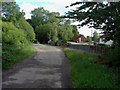
Chitty's Common
The short spur road that runs alongside Chitty's Common from Keens Lane.
Image: © Alan Hunt
Taken: 25 Jun 2011
0.08 miles
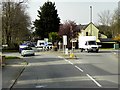
6
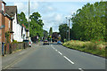
A322 Worplesdon Road
Heading north away from Guildford.
Image: © Robin Webster
Taken: 9 Jun 2019
0.08 miles


9
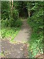
Chitty's Common
The southern end of the boardwalk that runs through this wet area of common land
Image: © Alan Hunt
Taken: 25 Jun 2011
0.09 miles
10
Roundabout at Worlesdon Road/Keens Lane Junction
Image: © David Dixon
Taken: 10 Apr 2015
0.10 miles