IMAGES TAKEN NEAR TO
Shepherds Hill, GUILDFORD, GU2 9RY
Introduction
This page details the photographs taken nearby to Shepherds Hill, GU2 9RY by members of the Geograph project.
The Geograph project started in 2005 with the aim of publishing, organising and preserving representative images for every square kilometre of Great Britain, Ireland and the Isle of Man.

There are currently over 7.5m images from over14,400 individuals and you can help contribute to the project by visiting https://www.geograph.org.uk
Image Map
Images are licensed for reuse under creativecommons.org/licenses/by-sa/2.0
Notes
- Clicking on the map will re-center to the selected point.
- The higher the marker number, the further away the image location is from the centre of the postcode.
Image Listing (44 Images Found)
Images are licensed for reuse under creativecommons.org/licenses/by-sa/2.0
Image
Details
Distance
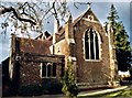
1
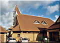
Emmanuel, Stoughton
Joined to the Old Church.
Image: © Michael FORD
Taken: Unknown
0.06 miles
4
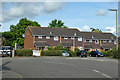
Houses on Galvins Close, Guildford
Off Shepherds Hill.
Image: © Robin Webster
Taken: 9 Jun 2019
0.07 miles

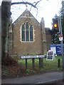
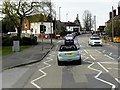
6
Worplesdon Road at the junction of Stoughton Road
Image: © David Howard
Taken: 7 Sep 2014
0.10 miles

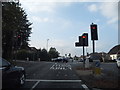
8
Worplesdon Road Junction With Stoughton Road
As the A322 leaves the Guildford suburbs, it climbs the hill towards Worplesdon.
Image: © David Dixon
Taken: 10 Apr 2015
0.10 miles
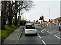
9
Pedestrian-Controlled Traffic Lights on Worplesdon Road
As the A322 leaves the Guildford suburbs, it climbs the hill towards Worplesdon.
Image: © David Dixon
Taken: 10 Apr 2015
0.11 miles
