IMAGES TAKEN NEAR TO
Barrack Road, GUILDFORD, GU2 9RU
Introduction
This page details the photographs taken nearby to Barrack Road, GU2 9RU by members of the Geograph project.
The Geograph project started in 2005 with the aim of publishing, organising and preserving representative images for every square kilometre of Great Britain, Ireland and the Isle of Man.

There are currently over 7.5m images from over14,400 individuals and you can help contribute to the project by visiting https://www.geograph.org.uk
Image Map
Images are licensed for reuse under creativecommons.org/licenses/by-sa/2.0
Notes
- Clicking on the map will re-center to the selected point.
- The higher the marker number, the further away the image location is from the centre of the postcode.
Image Listing (50 Images Found)
Images are licensed for reuse under creativecommons.org/licenses/by-sa/2.0
Image
Details
Distance
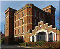
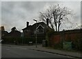
2
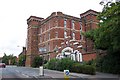
Stoughton Barracks, Guildford
This is the keep of Stoughton Barracks, built in 1876 as part of the army reforms carried out by Edward Cardwell, Gladstone's Secretary of State for War between 1870 and 1874, hence its nickname of Cardwell's Keep. Cardwell decided that each army regiment should be associated with a locality and Guildford was chosen as the headquarters of the 2nd Regiment of Foot – ‘The Queens’, one of the founding regiments of the British Army. In 1881 it became the Queen’s Royal West Surrey Regiment. In 1959, when it amalgamated with the East Surreys to become the Queen’s Royal Surrey Regiment, it left Stoughton. The Barracks then became a Regional Control Centre until the MOD moved out in 1983. It then remained derelict until being converted to residential use in 2000.
Image: © Ron Strutt
Taken: 26 Sep 2005
0.05 miles
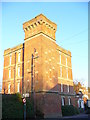
3
Stoughton Barracks: mid November 2021
Also see https://www.mymalayagallery.co.uk/page92.html
Image: © Basher Eyre
Taken: 18 Nov 2021
0.06 miles
4
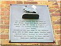
Plaque at Cardwell's Keep
On the wall beside the former gateway into Stoughton Barracks is this metal plaque with its relief model lamb and flag. The barracks has since been converted to flats.
http://www.queensroyalsurreys.org.uk/1661to1966/depots_g/depots_g.html
Image: © Colin Smith
Taken: 6 Dec 2008
0.06 miles
5
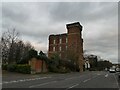
Cardwell's Keep
Cardwell's Keep from the south-east with the gates to the former Stoughton Barracks. Named after Sir Edward Cardwell, Gladstone's Secretary for War who put forward the policy that each county town should have a regiment associated with it, in this case the Queen's Royal 2nd Regiment of Foot, later renamed the Queen's Royal (West Surrey) regiment. The barracks were completed in 1876 under the supervision of Lieutenant Elliott Wood. The keep is built to the same design as one in Reading. Behind the keep is an open square, formerly the parade ground surrounded by the barrack housing. Both the keep and the housing have been converted to private dwellings. The actor Michael Caine will be familiar with this building as it was here that he trained before going to the Korean War.
Image: © Alan Hunt
Taken: 23 Nov 2012
0.06 miles
6
Cardwell's Keep
Victorian brick barracks block, built to house the local regiment. It was converted into flats in about 2000.
http://www.queensroyalsurreys.org.uk/1661to1966/depots_g/depots_g.html
Image: © Colin Smith
Taken: 6 Dec 2008
0.06 miles
7
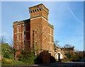
Cardwell's Keep
Cardwell's Keep on Stoughton Road from the south-west. A fine example of Victorian military architecture it is now used as private dwellings.
Image: © Alan Hunt
Taken: 23 Nov 2012
0.06 miles
8
Gateway to The Keep
Ornamental brick gateway, carrying insignia VR and date 1876. This led into Stoughton Barracks, built to house the Queen's (Second) Royal Regiment. About 2000, the Keep was redeveloped as flats.
http://www.queensroyalsurreys.org.uk/1661to1966/depots_g/depots_g.html
Image: © Colin Smith
Taken: 6 Dec 2008
0.07 miles
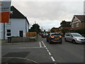
9
Lamppost at the junction of Stoughton Road and Scouts Lane
Image: © Basher Eyre
Taken: 18 Nov 2021
0.07 miles
10
Junction of Stoughton Road and Queens Drive
Image: © Basher Eyre
Taken: 18 Nov 2021
0.07 miles