IMAGES TAKEN NEAR TO
Grange Road, GUILDFORD, GU2 9QY
Introduction
This page details the photographs taken nearby to Grange Road, GU2 9QY by members of the Geograph project.
The Geograph project started in 2005 with the aim of publishing, organising and preserving representative images for every square kilometre of Great Britain, Ireland and the Isle of Man.

There are currently over 7.5m images from over14,400 individuals and you can help contribute to the project by visiting https://www.geograph.org.uk
Image Map
Images are licensed for reuse under creativecommons.org/licenses/by-sa/2.0
Notes
- Clicking on the map will re-center to the selected point.
- The higher the marker number, the further away the image location is from the centre of the postcode.
Image Listing (38 Images Found)
Images are licensed for reuse under creativecommons.org/licenses/by-sa/2.0
Image
Details
Distance
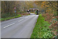
1
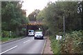
Low Bridge at Salt Box Road
When the railway was built across the heathland between Woking and Guildford the roads which it crossed were mere tracks. As a result, some of the bridges were built with very low headroom, and to take vehicles of any height at all, the roads had to be lowered beneath the bridges, with obvious potential for flooding.
Image: © Ron Strutt
Taken: 14 Sep 2005
0.11 miles
2
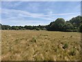
Grassland next to Salt Box Road
The outskirts of Guildford built up area.
Image: © James Emmans
Taken: 2 Jun 2020
0.13 miles
3

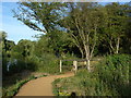
Stringer's Common
The sluice that carries the drainage ditch under the railway line
Image: © Alan Hunt
Taken: 13 Sep 2011
0.14 miles
4
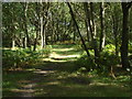
Stringer's Common
Woodland path near the railway line that marks the western edge of the common
Image: © Alan Hunt
Taken: 13 Sep 2011
0.15 miles
5
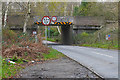
Bridge over Salt Box Road
The railway bridge over Salt Box Road near Bellfields in Guildford.
Image: © Alan Hunt
Taken: 2 Dec 2015
0.15 miles
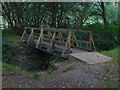
6
Britten's Pond
The footbridge over the stream that connects the main pond with the nursery pond to the southwest.
Image: © Alan Hunt
Taken: 8 Jul 2010
0.15 miles
7
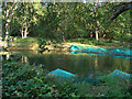
Britten's Pond
The small lake to the south west of the main pond, which appears to be used as a spawning area.
Image: © Alan Hunt
Taken: 8 Jul 2010
0.15 miles
8
Stringer's Common
A footbridge over the drain running into Brittens Pond south of Salt Box Road.
Image: © Alan Hunt
Taken: 13 Sep 2011
0.16 miles
9
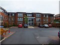
Queen Elizabeth Park Care Home
A purpose built private care home in a suburb of Guildford
Image: © David Smith
Taken: 20 Jul 2011
0.17 miles
10
Salt Box Road
Looking west along Salt Box Road towards the railway bridge. This road runs between the A322, Worplesdon Road and the A320, Woking Road north of Guildford.
Image: © Alan Hunt
Taken: 2 Dec 2015
0.17 miles