IMAGES TAKEN NEAR TO
Manor Road, GUILDFORD, GU2 9NL
Introduction
This page details the photographs taken nearby to Manor Road, GU2 9NL by members of the Geograph project.
The Geograph project started in 2005 with the aim of publishing, organising and preserving representative images for every square kilometre of Great Britain, Ireland and the Isle of Man.

There are currently over 7.5m images from over14,400 individuals and you can help contribute to the project by visiting https://www.geograph.org.uk
Image Map
Images are licensed for reuse under creativecommons.org/licenses/by-sa/2.0
Notes
- Clicking on the map will re-center to the selected point.
- The higher the marker number, the further away the image location is from the centre of the postcode.
Image Listing (139 Images Found)
Images are licensed for reuse under creativecommons.org/licenses/by-sa/2.0
Image
Details
Distance
1
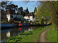
River Wey Navigation, Guildford
The house backing onto the navigation are on Weyside Road.
Image: © Alan Hunt
Taken: 17 Apr 2010
0.12 miles
2
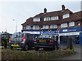
Shops in Woodbridge Hill
These three shops are arranged on a slight curve. Although the frntages are at angles to each other, the tiles on the roof have a curve and no sharp corners. The east-west grid line passes through the estate agency, so the centre of the photo and photographer are in SU9850.
Image: © David Smith
Taken: 20 Jul 2011
0.13 miles
3
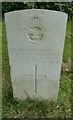
A mid-morning visit to Stoke New Cemetery (76)
The CWGC grave of Private R.A. Christmas https://www.cwgc.org/find-records/find-war-dead/casualty-details/401570/R%20A%20CHRISTMAS/
Image: © Basher Eyre
Taken: 2 Sep 2021
0.13 miles

5
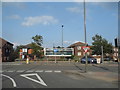
Aldershot Road at the junction of Worplesdon Road
Image: © David Howard
Taken: 7 Sep 2014
0.13 miles
6
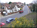
Manor Road
Woodbridge Hill area of suburban north Guildford. This area is much apart from the borough centre due to the alignment of the A3.
Image: © Colin Smith
Taken: 15 Mar 2008
0.14 miles


9

A mid-morning visit to Stoke New Cemetery (45)
CWGC grave of Private John Ansell https://www.cwgc.org/find-records/find-war-dead/casualty-details/401557/JOHN%20ANSELL/
Image: © Basher Eyre
Taken: 2 Sep 2021
0.15 miles
10

A mid-morning visit to Stoke New Cemetery (46)
CWGC grave of Private Christopher Ellender https://www.cwgc.org/find-records/find-war-dead/casualty-details/401577/CHRISTOPHER%20ELLENDER/
Image: © Basher Eyre
Taken: 2 Sep 2021
0.15 miles