IMAGES TAKEN NEAR TO
Taylors Field, MIDHURST, GU29 9PJ
Introduction
This page details the photographs taken nearby to Taylors Field, GU29 9PJ by members of the Geograph project.
The Geograph project started in 2005 with the aim of publishing, organising and preserving representative images for every square kilometre of Great Britain, Ireland and the Isle of Man.

There are currently over 7.5m images from over14,400 individuals and you can help contribute to the project by visiting https://www.geograph.org.uk
Image Map (Loading...)


Getting Data...Please wait
Leaflet Map data © OpenStreetMap
Images are licensed for reuse under creativecommons.org/licenses/by-sa/2.0
Notes
- Clicking on the map will re-center to the selected point.
- The higher the marker number, the further away the image location is from the centre of the postcode.
Image Listing (51 Images Found)
Images are licensed for reuse under creativecommons.org/licenses/by-sa/2.0
Image
Details
Distance
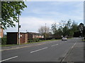
2
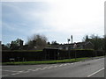
Bus stop on the corner of Taylors Field and New Road
Image: © Basher Eyre
Taken: 26 Apr 2008
0.04 miles

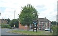
4

Welcome to Midhurst
Sign seen by people approaching up the Chichester Road
Image: © Basher Eyre
Taken: 26 Apr 2008
0.05 miles
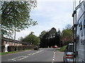
6
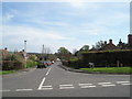
View along Bourne Road towards the Chichester Road
Image: © Basher Eyre
Taken: 26 Apr 2008
0.06 miles
7
Bend in the Chichester Road
Taken from end of Bourne Way
Image: © Basher Eyre
Taken: 26 Apr 2008
0.06 miles
9
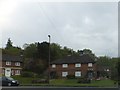
Semi-detached houses with gnomes, Midhurst
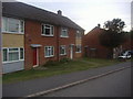
On the A286 at the edge of the town, a house and garden with gnomes.
Image: © David Smith
Taken: 28 Apr 2014
0.07 miles