IMAGES TAKEN NEAR TO
Edinburgh Square, MIDHURST, GU29 9NL
Introduction
This page details the photographs taken nearby to Edinburgh Square, GU29 9NL by members of the Geograph project.
The Geograph project started in 2005 with the aim of publishing, organising and preserving representative images for every square kilometre of Great Britain, Ireland and the Isle of Man.

There are currently over 7.5m images from over14,400 individuals and you can help contribute to the project by visiting https://www.geograph.org.uk
Image Map (Loading...)


Getting Data...Please wait
Leaflet Map data © OpenStreetMap
Images are licensed for reuse under creativecommons.org/licenses/by-sa/2.0
Notes
- Clicking on the map will re-center to the selected point.
- The higher the marker number, the further away the image location is from the centre of the postcode.
Image Listing (387 Images Found)
Images are licensed for reuse under creativecommons.org/licenses/by-sa/2.0
Image
Details
Distance
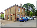
1
Crown House, Midhurst
Until recently the Crown public house.
Image: © David960
Taken: 16 Feb 2014
0.01 miles
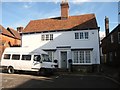
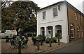
4
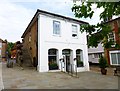
346 and 347 St Anne's Hill, Midhurst
Facing on to Edinburgh Square 346 and 347 form part of a group of Grade II listed buildings comprising 342 to 347 and Midhurst Centre. A group of estate cottages and a former Sunday school, in 1878 they were described as 'in course of erection'. The architect was EC Lee, and the builders Johnson & Sons of Chichester. The client is named as Jervoise Smith Esq, a member of the Smith family who owned the borough of Midhurst from 1795 until its re-acquisition by the Cowdray Estate in 1910.
Image: © Jo and Steve Turner
Taken: 23 Sep 2009
0.01 miles
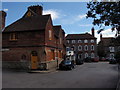
5
The back of the Old Town Hall in Sheep Lane
See Image] for a front view.
Midhurst was given a fire engine in 1730 and a second one purchased in 1865. They were kept behind this building and the horses pastured nearby on St Ann's Hill. The fire bells are still on the front of the building and can be seen at Image
Image: © Shazz
Taken: 10 Jul 2014
0.02 miles
6
The Old Town Hall, Market Square, Midhurst
Grade II Listed former Town Hall. Southwest of here is what is described as the 'Old Market House' that is clearly as described in the listing for it as 16th century (probably converted to a school 1672). See Image However the building here is described by local historians as a former open sided market house. A plot of land in the market place was granted to the burgesses by Sir Anthony Browne in 1552 for the building of a market house. By 1632 an open sided market building appears to exist here. All sources seem to agree this building was upgraded or rebuilt as a town hall between 1820 but probably more accurately 1843/4. Some indications are that one of the two buildings were enclosed in 1760. There is clearly confusion about the details of the two buildings.
Image: © Jo and Steve Turner
Taken: 23 Sep 2009
0.02 miles
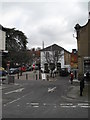
7
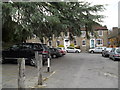
Cars parked outside Midhurst Parish Church
Image: © Basher Eyre
Taken: 6 Mar 2010
0.02 miles
8
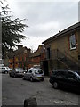
Cars opposite Midhurst Parish Church
Note the mustard windows on the buildings in the far distance- this means they belong to the Cowdray Estate.
Image: © Basher Eyre
Taken: 6 Mar 2010
0.02 miles
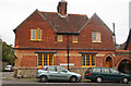
9
The Old Town Hall in Market Square
This was originally built as the Market House in the 16th century. In the 17th century a school for poor boys was founded upstairs. In 1760 the building was altered and became the Town Hall. The law court sat here and two cells were installed which still exist in the coffee house (see Image]). The building was altered yet again in 1843/4. This information is taken from A Midhurst Society Publication of 2006 entitled "The Market Square".
Image: © Shazz
Taken: 10 Jul 2014
0.02 miles
10
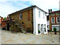
A view of the Old Town Hall showing the fire bells
This building has a chequered history including use by the fire brigade which moved out in 1955. The fire bells still hang at the top right of the front wall. See Image] for another view.
Image: © Shazz
Taken: 10 Jul 2014
0.02 miles