IMAGES TAKEN NEAR TO
Carron Lane, MIDHURST, GU29 9LB
Introduction
This page details the photographs taken nearby to Carron Lane, GU29 9LB by members of the Geograph project.
The Geograph project started in 2005 with the aim of publishing, organising and preserving representative images for every square kilometre of Great Britain, Ireland and the Isle of Man.

There are currently over 7.5m images from over14,400 individuals and you can help contribute to the project by visiting https://www.geograph.org.uk
Image Map (Loading...)


Getting Data...Please wait
Leaflet Map data © OpenStreetMap
Images are licensed for reuse under creativecommons.org/licenses/by-sa/2.0
Notes
- Clicking on the map will re-center to the selected point.
- The higher the marker number, the further away the image location is from the centre of the postcode.
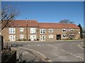
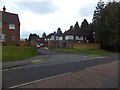
Image Listing (134 Images Found)
Images are licensed for reuse under creativecommons.org/licenses/by-sa/2.0
Image
Details
Distance
1
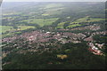
Midhurst: aerial 2014
Looking across Midhurst Common, the disused railway and workings bottom right. Cowdray Park and castle remains top right.
Image: © Chris
Taken: 15 Jun 2014
0.06 miles
4
Retirement Apartments, Petersfield Road
The apartments are located on the corner of Little Ashfield.
Image: © John Baker
Taken: 8 Apr 2016
0.12 miles
5
Oxford Court, Midhurst
On the site of the Oxford Arms public house in Bepton Road.
Image: © David960
Taken: 16 Mar 2014
0.13 miles
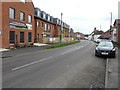
6
Netherwood Close, Midhurst
A modern estate of houses on the west of the town
Image: © David Smith
Taken: 2 May 2014
0.13 miles