IMAGES TAKEN NEAR TO
Bepton Road, MIDHURST, GU29 9FB
Introduction
This page details the photographs taken nearby to Bepton Road, GU29 9FB by members of the Geograph project.
The Geograph project started in 2005 with the aim of publishing, organising and preserving representative images for every square kilometre of Great Britain, Ireland and the Isle of Man.

There are currently over 7.5m images from over14,400 individuals and you can help contribute to the project by visiting https://www.geograph.org.uk
Image Map
Images are licensed for reuse under creativecommons.org/licenses/by-sa/2.0
Notes
- Clicking on the map will re-center to the selected point.
- The higher the marker number, the further away the image location is from the centre of the postcode.
Image Listing (368 Images Found)
Images are licensed for reuse under creativecommons.org/licenses/by-sa/2.0
Image
Details
Distance
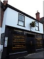


6
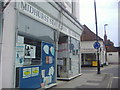
'Violet Designs', West Street, Midhurst
Image: © nick macneill
Taken: 15 Oct 2012
0.01 miles

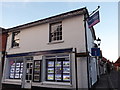
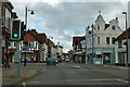
8
A272 crossroads in Midhurst town centre
The A272 is a major east/west road and Midhurst is an inevitable bottleneck. From her the road takes the left turn up Runscolds Hill towards Petworth.
Image: © Stuart Logan
Taken: 29 May 2014
0.01 miles
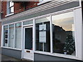
10
A286/A272 junction, Midhurst
The two roads share the centre of Midhurst, to split again north of the Rother in Easebourne.
Image: © Robin Webster
Taken: 25 Oct 2011
0.01 miles