IMAGES TAKEN NEAR TO
Iping, MIDHURST, GU29 0PH
Introduction
This page details the photographs taken nearby to GU29 0PH by members of the Geograph project.
The Geograph project started in 2005 with the aim of publishing, organising and preserving representative images for every square kilometre of Great Britain, Ireland and the Isle of Man.

There are currently over 7.5m images from over14,400 individuals and you can help contribute to the project by visiting https://www.geograph.org.uk
Image Map (Loading...)


Getting Data...Please wait
Leaflet Map data © OpenStreetMap
Images are licensed for reuse under creativecommons.org/licenses/by-sa/2.0
Notes
- Clicking on the map will re-center to the selected point.
- The higher the marker number, the further away the image location is from the centre of the postcode.
Image Listing (17 Images Found)
Images are licensed for reuse under creativecommons.org/licenses/by-sa/2.0
Image
Details
Distance

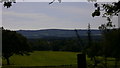
5
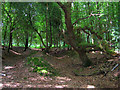
Oakham Common
There do seem to be a number of these hollows between the track and the slope out of shot to the right.
Image: © Simon Carey
Taken: 28 Jun 2008
0.14 miles
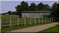
6
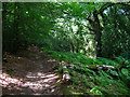
Oakham Common
At this point the restricted byway is on the western slope that leads down to a small deep valley of an unnamed tributary of the Rother.
Image: © Simon Carey
Taken: 28 Jun 2008
0.17 miles
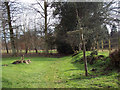
8
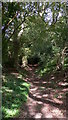
Looking north along Sharver's Lane
There were deer sitting in the shadows when I took this but I couldn't see them until they got up and ran when I moved.
Image: © Shazz
Taken: 21 Sep 2009
0.21 miles
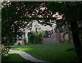
9
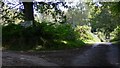
Sheep grazing in a field just off Iping Lane
Image: © Basher Eyre
Taken: 8 Oct 2020
0.21 miles