IMAGES TAKEN NEAR TO
Stedham, MIDHURST, GU29 0PA
Introduction
This page details the photographs taken nearby to GU29 0PA by members of the Geograph project.
The Geograph project started in 2005 with the aim of publishing, organising and preserving representative images for every square kilometre of Great Britain, Ireland and the Isle of Man.

There are currently over 7.5m images from over14,400 individuals and you can help contribute to the project by visiting https://www.geograph.org.uk
Image Map (Loading...)


Getting Data...Please wait
Leaflet Map data © OpenStreetMap
Images are licensed for reuse under creativecommons.org/licenses/by-sa/2.0
Notes
- Clicking on the map will re-center to the selected point.
- The higher the marker number, the further away the image location is from the centre of the postcode.
Image Listing (9 Images Found)
Images are licensed for reuse under creativecommons.org/licenses/by-sa/2.0
Image
Details
Distance
1
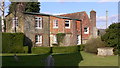
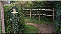
Corner of churchyard at Iping
The cottage beyond is I believe in SU8523.
Image: © Shazz
Taken: 2 Mar 2009
0.04 miles
2
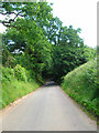
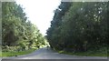
Iping Lane
Looking down the lane as it enters the northern fringes of Stedham Common on the way to its junction the A272 Midhurst-Petersfield road.
Image: © Simon Carey
Taken: 28 Jun 2008
0.11 miles
3
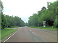
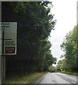
A272 junction with Iping Lane
To the right of this crossroads is Elsted Road.
Image: © Stuart Logan
Taken: 29 May 2014
0.15 miles
4
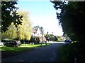
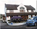
The Hamilton Arms, Stedham
A village pub with a Thai restaurant!
Image: © Keith Rose
Taken: 24 Sep 2005
0.15 miles