IMAGES TAKEN NEAR TO
Ingrams Green, MIDHURST, GU29 0LJ
Introduction
This page details the photographs taken nearby to GU29 0LJ by members of the Geograph project.
The Geograph project started in 2005 with the aim of publishing, organising and preserving representative images for every square kilometre of Great Britain, Ireland and the Isle of Man.

There are currently over 7.5m images from over14,400 individuals and you can help contribute to the project by visiting https://www.geograph.org.uk
Image Map (Loading...)


Getting Data...Please wait
Leaflet Map data © OpenStreetMap
Images are licensed for reuse under creativecommons.org/licenses/by-sa/2.0
Notes
- Clicking on the map will re-center to the selected point.
- The higher the marker number, the further away the image location is from the centre of the postcode.
Image Listing (8 Images Found)
Images are licensed for reuse under creativecommons.org/licenses/by-sa/2.0
Image
Details
Distance
1
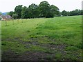
Footpath, Ingram's Green Lane
The footpath crosses fields to arrive at Brimbrook Lane.
Image: © Maigheach-gheal
Taken: 28 May 2009
0.05 miles
2
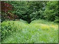
Bridleway, Ingram's Green Lane
The path takes riders and walkers into Henfield Wood.
Image: © Maigheach-gheal
Taken: 28 May 2009
0.06 miles
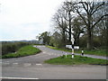
4
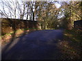
View north on Ingram's Green Lane from bridge over dismantled railway
Image: © Shazz
Taken: 12 Dec 2010
0.16 miles
5
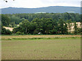
Windsock in the landscape
There seems to be no sign of a mown air strip or helicopter pad in the field of long grass, perhaps it is now disused. The South Downs form the horizon.
Image: © Robin Webster
Taken: 31 Jul 2012
0.20 miles
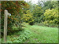
6
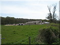
Farming and Stable Supplies in Ingrams Lane.
Namely
Image: © Basher Eyre
Taken: 26 Apr 2008
0.20 miles
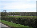
8
Looking from Ingrams Lane towards Elsted Marsh
Image: © Basher Eyre
Taken: 26 Apr 2008
0.24 miles