IMAGES TAKEN NEAR TO
Treyford, MIDHURST, GU29 0LB
Introduction
This page details the photographs taken nearby to GU29 0LB by members of the Geograph project.
The Geograph project started in 2005 with the aim of publishing, organising and preserving representative images for every square kilometre of Great Britain, Ireland and the Isle of Man.

There are currently over 7.5m images from over14,400 individuals and you can help contribute to the project by visiting https://www.geograph.org.uk
Image Map (Loading...)


Getting Data...Please wait
Leaflet Map data © OpenStreetMap
Images are licensed for reuse under creativecommons.org/licenses/by-sa/2.0
Notes
- Clicking on the map will re-center to the selected point.
- The higher the marker number, the further away the image location is from the centre of the postcode.
Image Listing (6 Images Found)
Images are licensed for reuse under creativecommons.org/licenses/by-sa/2.0
Image
Details
Distance
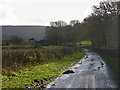
1
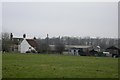
Field to the north of Treyford
The houses beyond the field are on a public footpath.
Image: © Shazz
Taken: 10 Dec 2010
0.01 miles
2
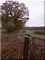
Footpath to New House Farm
The footpath uses the farm drive to pass New House Farm on its way to Didling.
Image: © Maigheach-gheal
Taken: 28 May 2009
0.09 miles
4
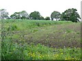
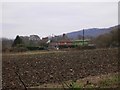
Footpath near Elsted
The footpath crosses arable fields on its way to Elsted. The crop is field beans.
Image: © Maigheach-gheal
Taken: 28 May 2009
0.16 miles