IMAGES TAKEN NEAR TO
Pine Walk, MIDHURST, GU29 0AS
Introduction
This page details the photographs taken nearby to Pine Walk, GU29 0AS by members of the Geograph project.
The Geograph project started in 2005 with the aim of publishing, organising and preserving representative images for every square kilometre of Great Britain, Ireland and the Isle of Man.

There are currently over 7.5m images from over14,400 individuals and you can help contribute to the project by visiting https://www.geograph.org.uk
Image Map (Loading...)


Getting Data...Please wait
Leaflet Map data © OpenStreetMap
Images are licensed for reuse under creativecommons.org/licenses/by-sa/2.0
Notes
- Clicking on the map will re-center to the selected point.
- The higher the marker number, the further away the image location is from the centre of the postcode.
Image Listing (7 Images Found)
Images are licensed for reuse under creativecommons.org/licenses/by-sa/2.0
Image
Details
Distance
1
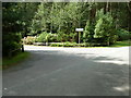
Sign for Hurst Park private housing estate
Image: © Dave Spicer
Taken: 29 Aug 2011
0.06 miles
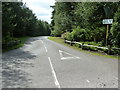
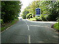
3
Scotland Lane
A dead end road that mainly serves Hurst park, a private housing estate.
Image: © Dave Spicer
Taken: 29 Aug 2011
0.13 miles
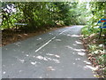
5
Closed entrance to the former King Edward VII hospital
The board gives the name of the current owners of the site and their plans for redevelopment. I always think the term 'acquired' sounds a little sinister.
Image: © Dave Spicer
Taken: 29 Aug 2011
0.16 miles
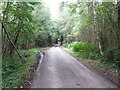
6
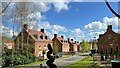
Houses at Brackenwood
There is a striking collection of upmarket, newly-built houses in this area.
Image: © Ian Hawfinch
Taken: 7 Apr 2022
0.20 miles
7
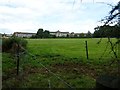
Disused King Edward VII Hospital
Planning application has been made to convert into apartments.
Image: © Dave Spicer
Taken: 29 Aug 2011
0.24 miles