IMAGES TAKEN NEAR TO
Little Platt, GUILDFORD, GU2 8JU
Introduction
This page details the photographs taken nearby to Little Platt, GU2 8JU by members of the Geograph project.
The Geograph project started in 2005 with the aim of publishing, organising and preserving representative images for every square kilometre of Great Britain, Ireland and the Isle of Man.

There are currently over 7.5m images from over14,400 individuals and you can help contribute to the project by visiting https://www.geograph.org.uk
Image Map
Images are licensed for reuse under creativecommons.org/licenses/by-sa/2.0
Notes
- Clicking on the map will re-center to the selected point.
- The higher the marker number, the further away the image location is from the centre of the postcode.
Image Listing (33 Images Found)
Images are licensed for reuse under creativecommons.org/licenses/by-sa/2.0
Image
Details
Distance
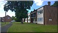
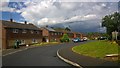
1
Little Platt
The junction of Little Platt with Applegarth Avenue
Image: © Alan Hunt
Taken: 9 Jun 2012
0.06 miles
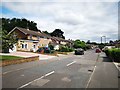
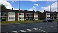
2
Park Barn Housing Estate
Post war council estate on the western edge of Guildford.
Image: © James Emmans
Taken: 22 Jun 2015
0.06 miles

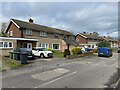
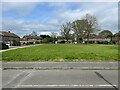
6
Broadstreet Common
Broadstreet Common from the entrance off Applegarth Avenue.
Image: © Alan Hunt
Taken: 9 Jun 2012
0.13 miles
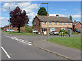
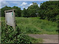
7
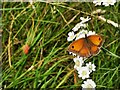
Gatekeeper Butterfly
Open common grassland is teaming with life on the edge of the Guildford urban sprawl.
Image: © James Emmans
Taken: 28 Jul 2019
0.15 miles