IMAGES TAKEN NEAR TO
Kirdford Road, PETWORTH, GU28 9PA
Introduction
This page details the photographs taken nearby to Kirdford Road, GU28 9PA by members of the Geograph project.
The Geograph project started in 2005 with the aim of publishing, organising and preserving representative images for every square kilometre of Great Britain, Ireland and the Isle of Man.

There are currently over 7.5m images from over14,400 individuals and you can help contribute to the project by visiting https://www.geograph.org.uk
Image Map
Images are licensed for reuse under creativecommons.org/licenses/by-sa/2.0
Notes
- Clicking on the map will re-center to the selected point.
- The higher the marker number, the further away the image location is from the centre of the postcode.
Image Listing (6 Images Found)
Images are licensed for reuse under creativecommons.org/licenses/by-sa/2.0
Image
Details
Distance
1
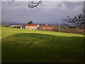
Same farm, different angle
This is Buckfold Farm seen from Glasshouse Lane. The original view is at http://www.geograph.org.uk/photo/257608.
Image: © Shazz
Taken: 16 Jan 2011
0.04 miles
2
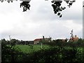
Buckfold Farm
Seen from Glasshouse Lane.
Image: © Andy Potter
Taken: 10 Oct 2006
0.05 miles
3
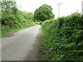
Cyclists on Glasshouse Lane
Glasshouse Lane runs north to Kirdford.
Image: © Dave Spicer
Taken: 8 May 2011
0.17 miles
4
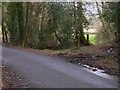
Glasshouse Lane (1)
Here seen with field entrance on the right.
Image: © Shazz
Taken: 16 Jan 2011
0.20 miles
5
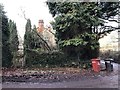
Wickers
The property known as Wickers. The clue was the name on the recycling bins.
Image: © Chris Thomas-Atkin
Taken: 27 Dec 2018
0.22 miles
6
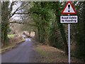
Warning proved right
This is Glasshouse Lane looking north.
Image: © Shazz
Taken: 16 Jan 2011
0.23 miles