IMAGES TAKEN NEAR TO
PETWORTH, GU28 9NX
Introduction
This page details the photographs taken nearby to GU28 9NX by members of the Geograph project.
The Geograph project started in 2005 with the aim of publishing, organising and preserving representative images for every square kilometre of Great Britain, Ireland and the Isle of Man.

There are currently over 7.5m images from over14,400 individuals and you can help contribute to the project by visiting https://www.geograph.org.uk
Image Map
Images are licensed for reuse under creativecommons.org/licenses/by-sa/2.0
Notes
- Clicking on the map will re-center to the selected point.
- The higher the marker number, the further away the image location is from the centre of the postcode.
Image Listing (3 Images Found)
Images are licensed for reuse under creativecommons.org/licenses/by-sa/2.0
Image
Details
Distance
1
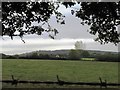
Field view to Benefold Farmhouse
The house is spelt as above while the farm is spelt Bennyfold
Image: © Dave Spicer
Taken: 17 Oct 2009
0.06 miles
2
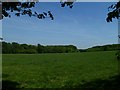
Field by Petsalls Copse
Petsalls Copse is straight ahead.
Image: © Shazz
Taken: 4 May 2011
0.21 miles