IMAGES TAKEN NEAR TO
Pipers Lane, PETWORTH, GU28 9LN
Introduction
This page details the photographs taken nearby to Pipers Lane, GU28 9LN by members of the Geograph project.
The Geograph project started in 2005 with the aim of publishing, organising and preserving representative images for every square kilometre of Great Britain, Ireland and the Isle of Man.

There are currently over 7.5m images from over14,400 individuals and you can help contribute to the project by visiting https://www.geograph.org.uk
Image Map
Images are licensed for reuse under creativecommons.org/licenses/by-sa/2.0
Notes
- Clicking on the map will re-center to the selected point.
- The higher the marker number, the further away the image location is from the centre of the postcode.
Image Listing (10 Images Found)
Images are licensed for reuse under creativecommons.org/licenses/by-sa/2.0
Image
Details
Distance
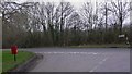
2
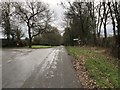
Lane Junction
The junction of Scratchings Lane with Piper’s Lane near Ebernoe.
Image: © Chris Thomas-Atkin
Taken: 30 Dec 2018
0.13 miles
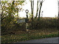
3
Postbox at the junction of Pipers Lane with Scratchings Lane
Image: © Dave Spicer
Taken: 31 Oct 2009
0.13 miles
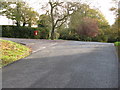
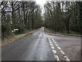
4
Road junction by Highnoons Farm
Here traffic on Scratchings Lane gives way to vehicles on Pipers Lane.
Image: © Shazz
Taken: 7 Mar 2009
0.14 miles
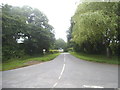
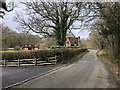
5
Turning to Ebernoe
The lane junction on Piper’s Lane with Streel’s Lane.
Image: © Chris Thomas-Atkin
Taken: 30 Dec 2018
0.15 miles
6
Signpost at road junction
The other two directions are classified
Image: © Dave Spicer
Taken: 31 Oct 2009
0.15 miles

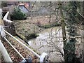
8
Wassell Mill
Approaching the old mill on Streel’s Lane.
Image: © Chris Thomas-Atkin
Taken: 30 Dec 2018
0.21 miles
9
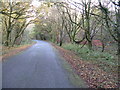
Pipers Lane south through Access Land called The Hoe
Image: © Dave Spicer
Taken: 31 Oct 2009
0.22 miles