IMAGES TAKEN NEAR TO
Balls Cross, PETWORTH, GU28 9JT
Introduction
This page details the photographs taken nearby to GU28 9JT by members of the Geograph project.
The Geograph project started in 2005 with the aim of publishing, organising and preserving representative images for every square kilometre of Great Britain, Ireland and the Isle of Man.

There are currently over 7.5m images from over14,400 individuals and you can help contribute to the project by visiting https://www.geograph.org.uk
Image Map
Images are licensed for reuse under creativecommons.org/licenses/by-sa/2.0
Notes
- Clicking on the map will re-center to the selected point.
- The higher the marker number, the further away the image location is from the centre of the postcode.
Image Listing (9 Images Found)
Images are licensed for reuse under creativecommons.org/licenses/by-sa/2.0
Image
Details
Distance
3
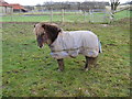
Four legged friend
This little fellow came to greet me as I was trying to get through the kissing gate. Once I agreed to take his photo, he let me in.
Image: © Dave Spicer
Taken: 19 Dec 2008
0.06 miles
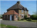
4
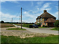
Crawfold Cottages
The cottages are at a crossways of rights-of-way. The road is the approach to Crawfold Farm, and only a bridleway for the public.
Image: © Robin Webster
Taken: 25 Jul 2011
0.08 miles
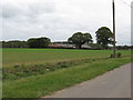
6
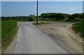
Bridleway and footpath junction near Crawfold Farm
Image: © Shazz
Taken: 4 May 2011
0.11 miles
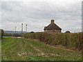
8

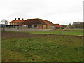
Fields near Kirdford
The buildings of Crawfold Farm are in the next gridsquare to the north.
Image: © Shazz
Taken: 4 May 2011
0.17 miles
9
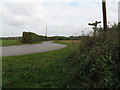
Bridleway junction between Elkham Farm and Crawfold Farm
Image: © Dave Spicer
Taken: 17 Oct 2009
0.24 miles