IMAGES TAKEN NEAR TO
Pipers Lane, PETWORTH, GU28 9JD
Introduction
This page details the photographs taken nearby to Pipers Lane, GU28 9JD by members of the Geograph project.
The Geograph project started in 2005 with the aim of publishing, organising and preserving representative images for every square kilometre of Great Britain, Ireland and the Isle of Man.

There are currently over 7.5m images from over14,400 individuals and you can help contribute to the project by visiting https://www.geograph.org.uk
Image Map
Images are licensed for reuse under creativecommons.org/licenses/by-sa/2.0
Notes
- Clicking on the map will re-center to the selected point.
- The higher the marker number, the further away the image location is from the centre of the postcode.
Image Listing (91 Images Found)
Images are licensed for reuse under creativecommons.org/licenses/by-sa/2.0
Image
Details
Distance
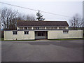
2
Northchapel village hall on Pipers Lane Northchapel
Image: © Dave Spicer
Taken: 24 Jan 2010
0.09 miles
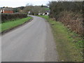
5
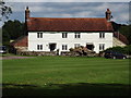
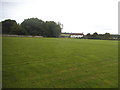
Shonks Farm
Old cottages on the large village green at Northchapel, West Sussex.
www.northchapel.org
Image: © Colin Smith
Taken: 5 Jul 2012
0.13 miles
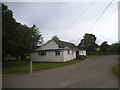
6
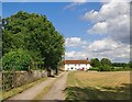
By the village green, Northchapel
View eastward, along the north side of the green.
Image: © Stefan Czapski
Taken: 19 Jul 2015
0.13 miles
7
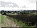
View south across the eastern half of Northchapel
Image: © Dave Spicer
Taken: 24 Jan 2010
0.13 miles
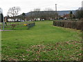
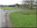
10
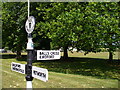
Northchapel, Sign by the Green.
The green lies by the main T-junction in the village. The green plays host to cricket and is also overlooked by the Deepwell Inn.
Image: © Colin Smith
Taken: 16 Jul 2006
0.16 miles