IMAGES TAKEN NEAR TO
Leaside, PETWORTH, GU28 9HD
Introduction
This page details the photographs taken nearby to Leaside, GU28 9HD by members of the Geograph project.
The Geograph project started in 2005 with the aim of publishing, organising and preserving representative images for every square kilometre of Great Britain, Ireland and the Isle of Man.

There are currently over 7.5m images from over14,400 individuals and you can help contribute to the project by visiting https://www.geograph.org.uk
Image Map
Images are licensed for reuse under creativecommons.org/licenses/by-sa/2.0
Notes
- Clicking on the map will re-center to the selected point.
- The higher the marker number, the further away the image location is from the centre of the postcode.
Image Listing (81 Images Found)
Images are licensed for reuse under creativecommons.org/licenses/by-sa/2.0
Image
Details
Distance

2
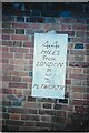
Old Milestone plate by A283, The Toll House
The Milestone plate is located on cottage wall on the East of the road. Parish of Northchapel (Chichester District). Metal plaque, Petworth plaque design, erected by the Petworth turnpike trust in the 19th Century, was perhaps cemented over.
Inscription reads:- 44 / MILES / FROM / LONDON / 5 / TO / PETWORTH
Milestone Society National ID: SX_LMP44
Image: © JR Dowding
Taken: 1 Feb 2007
0.12 miles
4
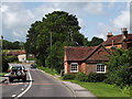
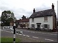
The Leaving of Northchapel
Looking northwards on the road to Guildford, the old toll house is on the right.
www.northchapel.org
Image: © Colin Smith
Taken: 5 Jul 2012
0.14 miles
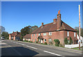
5
North House/Dove Cottage, Northchapel
North House is to the right and Dove Cottage to the left. Both are on the western side of the A283 opposite the village green.
Image: © Simon Carey
Taken: 2 Aug 2024
0.15 miles
6
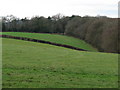
View west across hillside
The house in the distance is alongside the A283.
Image: © Dave Spicer
Taken: 24 Jan 2010
0.15 miles
7
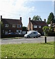
Friar Tuck's Cottage
Old cottage with an interesting name, on the main road through Northchapel village.
http://www.gravelroots.net/northchapel
Image: © Colin Smith
Taken: 5 Jul 2012
0.16 miles
9
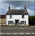
Friar Tuck Cottage, Northchapel
Dating from the 19th century and once the village stores. Located on the western side of the A283.
Image: © Simon Carey
Taken: 2 Aug 2024
0.17 miles
10
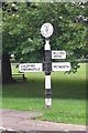
Old Direction Sign - Signpost by the A283, Northchapel
Annulus finial - 3 arms; WSCC parish halo by the A283, in parish of Northchapel (Chichester District), Northchapel, junction of the A283 with Pipers Lane, on the green.
To be surveyed
Milestone Society National ID: SX_SU9529
Image: © Milestone Society
Taken: Unknown
0.17 miles