IMAGES TAKEN NEAR TO
River Common, PETWORTH, GU28 9BB
Introduction
This page details the photographs taken nearby to GU28 9BB by members of the Geograph project.
The Geograph project started in 2005 with the aim of publishing, organising and preserving representative images for every square kilometre of Great Britain, Ireland and the Isle of Man.

There are currently over 7.5m images from over14,400 individuals and you can help contribute to the project by visiting https://www.geograph.org.uk
Image Map
Images are licensed for reuse under creativecommons.org/licenses/by-sa/2.0
Notes
- Clicking on the map will re-center to the selected point.
- The higher the marker number, the further away the image location is from the centre of the postcode.
Image Listing (9 Images Found)
Images are licensed for reuse under creativecommons.org/licenses/by-sa/2.0
Image
Details
Distance
1
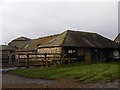
Outbuildings at Parkhurst Farm
One young heifer or bullock watched me with interest.
Image: © Shazz
Taken: 23 Jan 2010
0.03 miles
2
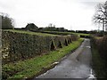
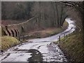
SE on the Upperton road to Parkhurst Farm
In front of the Farmhouse the wall is damaged allowing a view of Petworth Park Image
Image: © Dave Spicer
Taken: 27 Feb 2010
0.05 miles
3
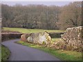
Breach in the Petworth Estate wall near Parkhurst Farmhouse
On this day I passed a number of such breaches. The earlier cold and snowy weather was probably responsible.
Image: © Shazz
Taken: 23 Jan 2010
0.07 miles
4
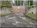
One of many locked estate gates into Petworth Park
Image: © Dave Spicer
Taken: 27 Feb 2010
0.09 miles
5
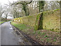
Support buttress on perimeter wall
The Petworth Park estate wall is approximately 9-11 miles in length.
Image: © Dave Spicer
Taken: 27 Feb 2010
0.14 miles
6
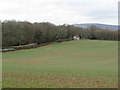
View NW from Parkhurst Farm
This view was only possible due a section of the park wall having collapsed.
Image: © Dave Spicer
Taken: 27 Feb 2010
0.17 miles
7
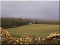
Field viewed through broken wall
The wall marks the perimeter of the Petworth Estate. The wall and the dwelling across the field are on the lane between Upperton and White's Green.
Image: © Shazz
Taken: 23 Jan 2010
0.23 miles
8
Stream from Pheasant Copse
The culvert for this stream which crosses the lane between White's Green and Upperton is unable to cope with the amount of water on this day and so some water flows above the road. Another view is at http://www.geograph.org.uk/photo/338079.
Image: © Shazz
Taken: 23 Jan 2010
0.24 miles
9
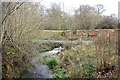
Stream leaving Pheasant Copse
The stream flows through a gap in the Petworth estate wall, and under the lane that follows the wall.
Image: © Robin Webster
Taken: 13 Feb 2007
0.24 miles