IMAGES TAKEN NEAR TO
River, PETWORTH, GU28 9AS
Introduction
This page details the photographs taken nearby to GU28 9AS by members of the Geograph project.
The Geograph project started in 2005 with the aim of publishing, organising and preserving representative images for every square kilometre of Great Britain, Ireland and the Isle of Man.

There are currently over 7.5m images from over14,400 individuals and you can help contribute to the project by visiting https://www.geograph.org.uk
Image Map
Images are licensed for reuse under creativecommons.org/licenses/by-sa/2.0
Notes
- Clicking on the map will re-center to the selected point.
- The higher the marker number, the further away the image location is from the centre of the postcode.
Image Listing (18 Images Found)
Images are licensed for reuse under creativecommons.org/licenses/by-sa/2.0
Image
Details
Distance
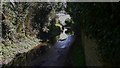
2
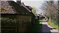
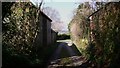
River Lane, River, West Sussex
Looking west along this attractive little road.
Image: © Shazz
Taken: 20 Mar 2009
0.03 miles
3
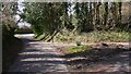
Junction of Janes Lane with River Lane
Janes Lane is on the right and a little further on the top of Brookfield Lane can be seen on the left.
Image: © Shazz
Taken: 20 Mar 2009
0.07 miles
4
Lane Junction near River
The junction of Janes Lane with River Lane in the hamlet of River.
Image: © Chris Thomas-Atkin
Taken: 9 Dec 2018
0.07 miles
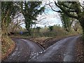
5
Lane Corner
A corner on River Lane near the property of Standlands.
Image: © Chris Thomas-Atkin
Taken: 9 Dec 2018
0.07 miles
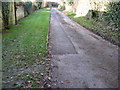
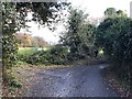
6
Flooded minor road
There has been no rain so perhaps a water main is leaking.
Image: © Shazz
Taken: 20 Mar 2009
0.10 miles
7
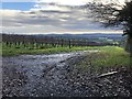
Vineyard beside River Lane
The vineyard with distant views beyond of the South Downs.
Image: © Chris Thomas-Atkin
Taken: 9 Dec 2018
0.12 miles