IMAGES TAKEN NEAR TO
The Harrows, PETWORTH, GU28 9AN
Introduction
This page details the photographs taken nearby to The Harrows, GU28 9AN by members of the Geograph project.
The Geograph project started in 2005 with the aim of publishing, organising and preserving representative images for every square kilometre of Great Britain, Ireland and the Isle of Man.

There are currently over 7.5m images from over14,400 individuals and you can help contribute to the project by visiting https://www.geograph.org.uk
Image Map
Images are licensed for reuse under creativecommons.org/licenses/by-sa/2.0
Notes
- Clicking on the map will re-center to the selected point.
- The higher the marker number, the further away the image location is from the centre of the postcode.
Image Listing (24 Images Found)
Images are licensed for reuse under creativecommons.org/licenses/by-sa/2.0
Image
Details
Distance
1
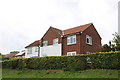
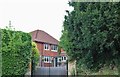
House on the A272, Tillington
The extension on the right has been added within the last year.
Image: © David Howard
Taken: 18 Aug 2018
0.05 miles
6
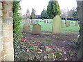
Tillington graveyard
The graveyard is situated about 200yds west of the church
Image: © Dave Spicer
Taken: 27 Dec 2009
0.16 miles
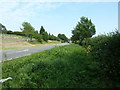
9
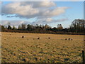
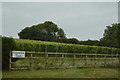
Sheep grazing in field west of Tillington
Image: © Dave Spicer
Taken: 27 Dec 2009
0.19 miles
10
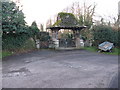
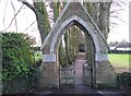
Lych gate eastern entrance to graveyard
I hope the trailer is not used for transportation from the church
Image: © Dave Spicer
Taken: 27 Dec 2009
0.19 miles