IMAGES TAKEN NEAR TO
Tillington, PETWORTH, GU28 0RA
Introduction
This page details the photographs taken nearby to GU28 0RA by members of the Geograph project.
The Geograph project started in 2005 with the aim of publishing, organising and preserving representative images for every square kilometre of Great Britain, Ireland and the Isle of Man.

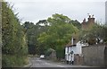
There are currently over 7.5m images from over14,400 individuals and you can help contribute to the project by visiting https://www.geograph.org.uk
Image Map
Images are licensed for reuse under creativecommons.org/licenses/by-sa/2.0
Notes
- Clicking on the map will re-center to the selected point.
- The higher the marker number, the further away the image location is from the centre of the postcode.
Image Listing (116 Images Found)
Images are licensed for reuse under creativecommons.org/licenses/by-sa/2.0
Image
Details
Distance
2
Footpath from the Church
This path heads through the Churchyard before meeting the A272.
Image: © DS Pugh
Taken: 8 Dec 2018
0.03 miles
3
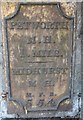
Old Milepost by the A272, Tillington
Cast iron plate by the A272, in parish of Tillington (Chichester District), Tillington Cottage, 100m East of junction with Upperton Road, in stone boundary wall, on South side of road. Petworth plaque, erected by an unknown authority in the 19th century.
Inscription reads:-
PETWORTH
M.H.
1. MILE.
{diamond}
MIDHURST
M.H.
M.F.R.
5.5.4.
Grade II listed.
List Entry Number: 1217635 https://historicengland.org.uk/listing/the-list/list-entry/1217635
Milestone Society National ID: SX_BRPF29
Image: © Alan Savill
Taken: 11 Aug 2015
0.03 miles
4
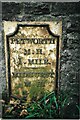
Old Milepost by the A272, Tillington
Cast iron plate by the A272, in parish of Tillington (Chichester District), Tillington Cottage, 100m East of junction with Upperton Road, in stone boundary wall, on South side of road. Petworth plaque, erected by an unknown authority in the 19th century.
Inscription reads:-
PETWORTH
M.H.
1. MILE.
{diamond}
MIDHURST
M.H.
M.F.R.
5.5.4.
Grade II listed.
List Entry Number: 1217635 https://historicengland.org.uk/listing/the-list/list-entry/1217635
Milestone Society National ID: SX_BRPF29
Image: © JR Dowding
Taken: 1 Jan 2007
0.03 miles
5
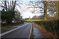
A272 approaching Tillington
The Church is prominent.
Image: © DS Pugh
Taken: 9 Dec 2018
0.04 miles
6
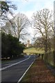
A272 near Tillington
Looking along the A272 with All Hallows Church behind.
Image: © DS Pugh
Taken: 8 Dec 2018
0.04 miles
7
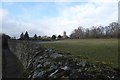
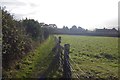
Over the wall
Looking over the wall towards the village of Tillington and All Hallows Church.
Image: © DS Pugh
Taken: 8 Dec 2018
0.05 miles
8
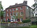
Tillington House, Tillington
Early C19th, of stone rubble. The listing appears to imply that the main facade is only painted red brick, but if so it's very convincingly done. Grade II* listed.
Image: © Stephen Richards
Taken: Unknown
0.05 miles

10
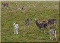
Deer at Petworth
Looking over the wall from the A272 into Petworth Park.
Image: © DS Pugh
Taken: 8 Dec 2018
0.05 miles